| This article includes a list of references, related reading, or external links, but its sources remain unclear because it lacks inline citations. Please help improve this article by introducing more precise citations. (December 2023) (Learn how and when to remove this message) |
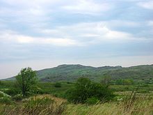
Azov Upland is a plateau or range of hills in East Ukraine within the Donetsk and Zaporizhia oblasts.
To the north it borders Dnieper Lowland, to northeast – Donets Ridge, southwest – Black Sea Lowland, south – Azov Lowland. Elevation varies between 200–250 m (660–820 ft).
Interesting features are mounds locally known as mohyly similar to Russian equivalent of kurgan. The highest hill is Belmak-Mohyla (Horyla) that rises at 327 m (1,073 ft).
The climate is similar to Donets Ridge. Soils are categorized as chernozem of poor or medium humus. Vegetation is a fescue-feather-grass steppe.
References
External links
- Azov Upland at the Encyclopedia of Ukraine
- Azov Upland at the Encyclopædia Britannica
- Azov Upland at the Great Soviet Encyclopedia
| Geographic regions of Ukraine | |||||||||||||||
|---|---|---|---|---|---|---|---|---|---|---|---|---|---|---|---|
| Geography of Ukraine | |||||||||||||||
| East European Plain |
| ||||||||||||||
| Ukrainian Carpathians |
| ||||||||||||||
47°19′53″N 36°34′45″E / 47.3315°N 36.5791°E / 47.3315; 36.5791
This article about a location in Ukraine is a stub. You can help Misplaced Pages by expanding it. |