| An editor has nominated this article for deletion. You are welcome to participate in the deletion discussion, which will decide whether or not to retain it.Feel free to improve the article, but do not remove this notice before the discussion is closed. For more information, see the guide to deletion. Find sources: "B1" New York City bus – news · newspapers · books · scholar · JSTOR%5B%5BWikipedia%3AArticles+for+deletion%2FB1+%28New+York+City+bus%29%5D%5DAFD |
This article has multiple issues. Please help improve it or discuss these issues on the talk page. (Learn how and when to remove these messages)
|
| b1 | ||||||||||||||||||||||||||||||||||||||||||||||||||||||||||||||||||||||||||||||||||||||||||||||||||||||||||||||||||||||||||||||||||||||||||||||||||||||||||||||||||||||||||||||||||||||||||||||||||||||||||||||||||||||||||||||||||||||||||||||||||||||||||||||||||||||||||||||||||||||||||||||||||||||||||||||||||||||||||||||||||||||||||||||||||||||||||||||||||||||||||||||||||||||||||||||||||||||||||||||||||||||||||||||||
|---|---|---|---|---|---|---|---|---|---|---|---|---|---|---|---|---|---|---|---|---|---|---|---|---|---|---|---|---|---|---|---|---|---|---|---|---|---|---|---|---|---|---|---|---|---|---|---|---|---|---|---|---|---|---|---|---|---|---|---|---|---|---|---|---|---|---|---|---|---|---|---|---|---|---|---|---|---|---|---|---|---|---|---|---|---|---|---|---|---|---|---|---|---|---|---|---|---|---|---|---|---|---|---|---|---|---|---|---|---|---|---|---|---|---|---|---|---|---|---|---|---|---|---|---|---|---|---|---|---|---|---|---|---|---|---|---|---|---|---|---|---|---|---|---|---|---|---|---|---|---|---|---|---|---|---|---|---|---|---|---|---|---|---|---|---|---|---|---|---|---|---|---|---|---|---|---|---|---|---|---|---|---|---|---|---|---|---|---|---|---|---|---|---|---|---|---|---|---|---|---|---|---|---|---|---|---|---|---|---|---|---|---|---|---|---|---|---|---|---|---|---|---|---|---|---|---|---|---|---|---|---|---|---|---|---|---|---|---|---|---|---|---|---|---|---|---|---|---|---|---|---|---|---|---|---|---|---|---|---|---|---|---|---|---|---|---|---|---|---|---|---|---|---|---|---|---|---|---|---|---|---|---|---|---|---|---|---|---|---|---|---|---|---|---|---|---|---|---|---|---|---|---|---|---|---|---|---|---|---|---|---|---|---|---|---|---|---|---|---|---|---|---|---|---|---|---|---|---|---|---|---|---|---|---|---|---|---|---|---|---|---|---|---|---|---|---|---|---|---|---|---|---|---|---|---|---|---|---|---|---|---|---|---|---|---|---|---|---|---|---|---|---|---|---|---|---|---|---|---|---|---|---|---|---|---|---|---|---|---|---|---|---|---|---|---|---|---|---|---|---|---|---|---|---|---|---|---|---|---|---|---|---|---|---|---|---|
| 86th Street Line (Brooklyn) | ||||||||||||||||||||||||||||||||||||||||||||||||||||||||||||||||||||||||||||||||||||||||||||||||||||||||||||||||||||||||||||||||||||||||||||||||||||||||||||||||||||||||||||||||||||||||||||||||||||||||||||||||||||||||||||||||||||||||||||||||||||||||||||||||||||||||||||||||||||||||||||||||||||||||||||||||||||||||||||||||||||||||||||||||||||||||||||||||||||||||||||||||||||||||||||||||||||||||||||||||||||||||||||||||
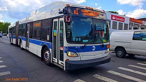
 A 2013 New Flyer XD60 (4777) in Bensonhurst on the B1 to Kingsborough Community College. A 2013 New Flyer XD60 (4777) in Bensonhurst on the B1 to Kingsborough Community College. | ||||||||||||||||||||||||||||||||||||||||||||||||||||||||||||||||||||||||||||||||||||||||||||||||||||||||||||||||||||||||||||||||||||||||||||||||||||||||||||||||||||||||||||||||||||||||||||||||||||||||||||||||||||||||||||||||||||||||||||||||||||||||||||||||||||||||||||||||||||||||||||||||||||||||||||||||||||||||||||||||||||||||||||||||||||||||||||||||||||||||||||||||||||||||||||||||||||||||||||||||||||||||||||||||
| Overview | ||||||||||||||||||||||||||||||||||||||||||||||||||||||||||||||||||||||||||||||||||||||||||||||||||||||||||||||||||||||||||||||||||||||||||||||||||||||||||||||||||||||||||||||||||||||||||||||||||||||||||||||||||||||||||||||||||||||||||||||||||||||||||||||||||||||||||||||||||||||||||||||||||||||||||||||||||||||||||||||||||||||||||||||||||||||||||||||||||||||||||||||||||||||||||||||||||||||||||||||||||||||||||||||||
| System | MTA Regional Bus Operations | |||||||||||||||||||||||||||||||||||||||||||||||||||||||||||||||||||||||||||||||||||||||||||||||||||||||||||||||||||||||||||||||||||||||||||||||||||||||||||||||||||||||||||||||||||||||||||||||||||||||||||||||||||||||||||||||||||||||||||||||||||||||||||||||||||||||||||||||||||||||||||||||||||||||||||||||||||||||||||||||||||||||||||||||||||||||||||||||||||||||||||||||||||||||||||||||||||||||||||||||||||||||||||||||
| Operator | New York City Transit Authority | |||||||||||||||||||||||||||||||||||||||||||||||||||||||||||||||||||||||||||||||||||||||||||||||||||||||||||||||||||||||||||||||||||||||||||||||||||||||||||||||||||||||||||||||||||||||||||||||||||||||||||||||||||||||||||||||||||||||||||||||||||||||||||||||||||||||||||||||||||||||||||||||||||||||||||||||||||||||||||||||||||||||||||||||||||||||||||||||||||||||||||||||||||||||||||||||||||||||||||||||||||||||||||||||
| Garage | Ulmer Park Depot | |||||||||||||||||||||||||||||||||||||||||||||||||||||||||||||||||||||||||||||||||||||||||||||||||||||||||||||||||||||||||||||||||||||||||||||||||||||||||||||||||||||||||||||||||||||||||||||||||||||||||||||||||||||||||||||||||||||||||||||||||||||||||||||||||||||||||||||||||||||||||||||||||||||||||||||||||||||||||||||||||||||||||||||||||||||||||||||||||||||||||||||||||||||||||||||||||||||||||||||||||||||||||||||||
| Vehicle | New Flyer Xcelsior XD60 (main vehicle) New Flyer Xcelsior XD40 (supplemental service) | |||||||||||||||||||||||||||||||||||||||||||||||||||||||||||||||||||||||||||||||||||||||||||||||||||||||||||||||||||||||||||||||||||||||||||||||||||||||||||||||||||||||||||||||||||||||||||||||||||||||||||||||||||||||||||||||||||||||||||||||||||||||||||||||||||||||||||||||||||||||||||||||||||||||||||||||||||||||||||||||||||||||||||||||||||||||||||||||||||||||||||||||||||||||||||||||||||||||||||||||||||||||||||||||
| Began service | 1894 (Streetcar Line 31) April 1919 (B1) | |||||||||||||||||||||||||||||||||||||||||||||||||||||||||||||||||||||||||||||||||||||||||||||||||||||||||||||||||||||||||||||||||||||||||||||||||||||||||||||||||||||||||||||||||||||||||||||||||||||||||||||||||||||||||||||||||||||||||||||||||||||||||||||||||||||||||||||||||||||||||||||||||||||||||||||||||||||||||||||||||||||||||||||||||||||||||||||||||||||||||||||||||||||||||||||||||||||||||||||||||||||||||||||||
| Ended service | August 12, 1948 (Streetcar Line 31) | |||||||||||||||||||||||||||||||||||||||||||||||||||||||||||||||||||||||||||||||||||||||||||||||||||||||||||||||||||||||||||||||||||||||||||||||||||||||||||||||||||||||||||||||||||||||||||||||||||||||||||||||||||||||||||||||||||||||||||||||||||||||||||||||||||||||||||||||||||||||||||||||||||||||||||||||||||||||||||||||||||||||||||||||||||||||||||||||||||||||||||||||||||||||||||||||||||||||||||||||||||||||||||||||
| Route | ||||||||||||||||||||||||||||||||||||||||||||||||||||||||||||||||||||||||||||||||||||||||||||||||||||||||||||||||||||||||||||||||||||||||||||||||||||||||||||||||||||||||||||||||||||||||||||||||||||||||||||||||||||||||||||||||||||||||||||||||||||||||||||||||||||||||||||||||||||||||||||||||||||||||||||||||||||||||||||||||||||||||||||||||||||||||||||||||||||||||||||||||||||||||||||||||||||||||||||||||||||||||||||||||
| Locale | Brooklyn, New York, U.S. | |||||||||||||||||||||||||||||||||||||||||||||||||||||||||||||||||||||||||||||||||||||||||||||||||||||||||||||||||||||||||||||||||||||||||||||||||||||||||||||||||||||||||||||||||||||||||||||||||||||||||||||||||||||||||||||||||||||||||||||||||||||||||||||||||||||||||||||||||||||||||||||||||||||||||||||||||||||||||||||||||||||||||||||||||||||||||||||||||||||||||||||||||||||||||||||||||||||||||||||||||||||||||||||||
| Communities served | Bay Ridge, Dyker Heights, Bensonhurst, Bath Beach, Gravesend, Brighton Beach, Manhattan Beach | |||||||||||||||||||||||||||||||||||||||||||||||||||||||||||||||||||||||||||||||||||||||||||||||||||||||||||||||||||||||||||||||||||||||||||||||||||||||||||||||||||||||||||||||||||||||||||||||||||||||||||||||||||||||||||||||||||||||||||||||||||||||||||||||||||||||||||||||||||||||||||||||||||||||||||||||||||||||||||||||||||||||||||||||||||||||||||||||||||||||||||||||||||||||||||||||||||||||||||||||||||||||||||||||
| Start | Bay Ridge - 86th Street & 4th Avenue | |||||||||||||||||||||||||||||||||||||||||||||||||||||||||||||||||||||||||||||||||||||||||||||||||||||||||||||||||||||||||||||||||||||||||||||||||||||||||||||||||||||||||||||||||||||||||||||||||||||||||||||||||||||||||||||||||||||||||||||||||||||||||||||||||||||||||||||||||||||||||||||||||||||||||||||||||||||||||||||||||||||||||||||||||||||||||||||||||||||||||||||||||||||||||||||||||||||||||||||||||||||||||||||||
| Via | 86th Street, Ocean Parkway, Brighton Beach Avenue | |||||||||||||||||||||||||||||||||||||||||||||||||||||||||||||||||||||||||||||||||||||||||||||||||||||||||||||||||||||||||||||||||||||||||||||||||||||||||||||||||||||||||||||||||||||||||||||||||||||||||||||||||||||||||||||||||||||||||||||||||||||||||||||||||||||||||||||||||||||||||||||||||||||||||||||||||||||||||||||||||||||||||||||||||||||||||||||||||||||||||||||||||||||||||||||||||||||||||||||||||||||||||||||||
| End | Manhattan Beach – Kingsborough Community College | |||||||||||||||||||||||||||||||||||||||||||||||||||||||||||||||||||||||||||||||||||||||||||||||||||||||||||||||||||||||||||||||||||||||||||||||||||||||||||||||||||||||||||||||||||||||||||||||||||||||||||||||||||||||||||||||||||||||||||||||||||||||||||||||||||||||||||||||||||||||||||||||||||||||||||||||||||||||||||||||||||||||||||||||||||||||||||||||||||||||||||||||||||||||||||||||||||||||||||||||||||||||||||||||
| Length | 6.8 miles (10.9 km) | |||||||||||||||||||||||||||||||||||||||||||||||||||||||||||||||||||||||||||||||||||||||||||||||||||||||||||||||||||||||||||||||||||||||||||||||||||||||||||||||||||||||||||||||||||||||||||||||||||||||||||||||||||||||||||||||||||||||||||||||||||||||||||||||||||||||||||||||||||||||||||||||||||||||||||||||||||||||||||||||||||||||||||||||||||||||||||||||||||||||||||||||||||||||||||||||||||||||||||||||||||||||||||||||
| Service | ||||||||||||||||||||||||||||||||||||||||||||||||||||||||||||||||||||||||||||||||||||||||||||||||||||||||||||||||||||||||||||||||||||||||||||||||||||||||||||||||||||||||||||||||||||||||||||||||||||||||||||||||||||||||||||||||||||||||||||||||||||||||||||||||||||||||||||||||||||||||||||||||||||||||||||||||||||||||||||||||||||||||||||||||||||||||||||||||||||||||||||||||||||||||||||||||||||||||||||||||||||||||||||||||
| Operates | 24 hours | |||||||||||||||||||||||||||||||||||||||||||||||||||||||||||||||||||||||||||||||||||||||||||||||||||||||||||||||||||||||||||||||||||||||||||||||||||||||||||||||||||||||||||||||||||||||||||||||||||||||||||||||||||||||||||||||||||||||||||||||||||||||||||||||||||||||||||||||||||||||||||||||||||||||||||||||||||||||||||||||||||||||||||||||||||||||||||||||||||||||||||||||||||||||||||||||||||||||||||||||||||||||||||||||
| Annual patronage | 3,764,062 (2023) | |||||||||||||||||||||||||||||||||||||||||||||||||||||||||||||||||||||||||||||||||||||||||||||||||||||||||||||||||||||||||||||||||||||||||||||||||||||||||||||||||||||||||||||||||||||||||||||||||||||||||||||||||||||||||||||||||||||||||||||||||||||||||||||||||||||||||||||||||||||||||||||||||||||||||||||||||||||||||||||||||||||||||||||||||||||||||||||||||||||||||||||||||||||||||||||||||||||||||||||||||||||||||||||||
| Transfers | Yes | |||||||||||||||||||||||||||||||||||||||||||||||||||||||||||||||||||||||||||||||||||||||||||||||||||||||||||||||||||||||||||||||||||||||||||||||||||||||||||||||||||||||||||||||||||||||||||||||||||||||||||||||||||||||||||||||||||||||||||||||||||||||||||||||||||||||||||||||||||||||||||||||||||||||||||||||||||||||||||||||||||||||||||||||||||||||||||||||||||||||||||||||||||||||||||||||||||||||||||||||||||||||||||||||
| Timetable | B1 | |||||||||||||||||||||||||||||||||||||||||||||||||||||||||||||||||||||||||||||||||||||||||||||||||||||||||||||||||||||||||||||||||||||||||||||||||||||||||||||||||||||||||||||||||||||||||||||||||||||||||||||||||||||||||||||||||||||||||||||||||||||||||||||||||||||||||||||||||||||||||||||||||||||||||||||||||||||||||||||||||||||||||||||||||||||||||||||||||||||||||||||||||||||||||||||||||||||||||||||||||||||||||||||||
| ||||||||||||||||||||||||||||||||||||||||||||||||||||||||||||||||||||||||||||||||||||||||||||||||||||||||||||||||||||||||||||||||||||||||||||||||||||||||||||||||||||||||||||||||||||||||||||||||||||||||||||||||||||||||||||||||||||||||||||||||||||||||||||||||||||||||||||||||||||||||||||||||||||||||||||||||||||||||||||||||||||||||||||||||||||||||||||||||||||||||||||||||||||||||||||||||||||||||||||||||||||||||||||||||
The 86th Street Line is a public transit line in Brooklyn, New York, running mostly along 86th Street. Originally a streetcar line, it is now the B1 86th Street bus route operated by the New York City Transit Authority.
Route description

The B1 begins at 4th Avenue and 87th Street in Bay Ridge and then turns right onto 86th Street. It then travels down the full length of 86th Street until McDonald Avenue, where it turns onto Avenue X. The B1 then turns right onto Ocean Parkway and continues until turning left onto Brighton Beach Avenue, sharing the street with the B68. It continues until turning right at Corbin Place and left onto Oriental Blvd. The route then continues until it ends at Kingsborough Community College.
History
Streetcar line

The 86th Street streetcar line or Streetcar Line #31 was built by the Nassau Electric Railroad in 1894 to make more profits for the company. The company was later leased by the Brooklyn-Manhattan Transit Corporation. In 1929 the company made a subsidiary company, the Brooklyn and Queens Transit Corporation, to run multiple Streetcar lines one of which was the 86th Streetcar Line. The line ran entirely on surface level except for the northern terminal where it went onto an island platform. The 86th Streetcar Line had connections to multiple lines including the Bay Ridge Line, West End Line and the Fifth Avenue Line. In 1930, new tracks were made that split from the West End Line at 24th Avenue and went onto a right of way path used by trolleys to get to the Unionville Depot and onto Crospey Avenue. The 86th Street line would then later merge back with the West End Line at the intersection of Crospey and Stillwell Avenues.
The 86th Street streetcar line closed on August 12, 1948, was replaced with bus service and demolished some time later.
Pre-1930 Stations list
| Neighborhood | Station | Type | Tracks | Services | Opened | Transfers and notes |
|---|---|---|---|---|---|---|
| Bay Ridge | ||||||
| 65th Street Terminal Station | local | all | 86th Street Line | 1894 | Demolished 1948 | |
| Ramp down from elevated station | ||||||
| 67th Street | local | all | 86th Street Line | 1894 | Demolished 1948 | |
| Bay Ridge Avenue | local | all | 86th Street Line | 1894 | Transfer to Bay Ridge Avenue line | |
| 4th Avenue | local | all | 86th Street Line | 1894 | Demolished 1948 | |
| 5th Avenue | local | all | 86th Street Line | 1894 | Demolished 1948 | |
| 72nd Street | local | all | 86th Street Line | 1894 | Demolished 1948 | |
| Bay Ridge Parkway | local | all | 86th Street Line | 1894 | Demolished 1948 | |
| 77th Street | local | all | 86th Street Line | 1894 | Demolished 1948 | |
| 80th Street | local | all | 86th Street Line | 1894 | Demolished 1948 | |
| 83rd Street | local | all | 86th Street Line | 1894 | Demolished 1948 | |
| Fifth Avenue | local | all | 86th Street Line | 1894 | Demolished 1948 | |
| Fort Hamilton Parkway | local | all | 86th Street Line | 1894 | Demolished 1948 | |
| Dyker Heights | ||||||
| 7th Avenue | local | all | 86th Street Line | 1894 | Demolished 1948 | |
| 12th Avenue | local | all | 86th Street Line | 1894 | Demolished 1948 | |
| 14th Avenue-86th Street | local | all | 86th Street Line | 1894 | Demolished 1948 | |
| Benson Avenue | local | all | 86th Street Line | 1894 | Demolished 1948 | |
| 14th Avenue | local | all | 86th Street Line | 1894 | Demolished 1948 | |
| Bath Beach | ||||||
| 15th Avenue | local | all | 86th Street Line | 1894 | Demolished 1948 | |
| 16th Avenue | local | all | 86th Street Line | 1894 | Demolished 1948 | |
| 17th Avenue | local | all | 86th Street Line | 1894 | Demolished 1948 | |
| Tracks Merge at Bay 19th Street with the West End Line | ||||||
| Bay 18th Street | local | all | 86th Street Line | 1894 | Connections to the West End Line surface | |
| 20th Avenue | local | all | 86th Street Line | 1894 | Connections to the West End Line surface | |
| 21st Avenue | local | all | 86th Street Line | 1894 | Connections to the West End Line surface | |
| Bay Parkway | local | all | 86th Street Line | 1894 | Connections to the West End Line surface | |
| 23rd Avenue | local | all | 86th Street Line | 1894 | Connections to the West End Line surface | |
| 24th Avenue | local | all | 86th Street Line | 1894 | Connections to the West End Line surface | |
| 25th Avenue | local | all | 86th Street Line | 1894 | Connections to the West End Line surface | |
| Track Splits to Unionville Depot | ||||||
| Bay 41st Street | local | all | 86th Street Line | 1894 | Connections to the West End Line surface | |
| Bay 44th Street | local | all | 86th Street Line | 1894 | Connections to the West End Line surface | |
| Gravesend | ||||||
| 28th Avenue | local | all | 86th Street Line | 1894 | Connections to the West End Line surface | |
| Harway Avenue | local | all | 86th Street Line | 1894 | Demolished 1948 | |
| Avenue Z | local | all | 86th Street Line | 1894 | Demolished 1948 | |
| Coney Island | ||||||
| Neptune Avenue | local | all | 86th Street Line | 1894 | Demolished 1948 | |
| Stillwell Avenue | local | all | 86th Street Line | 1894 | Connections to the West End Line surface, Sea Gate, Norton's Point and Sea Beach Line (As of 1948) | |
Bus line

Bus service in the Sheepshead Bay area was started in April 1919 by Plum Beach Auto Stage. Trolley service had not reached the area, due to its sparse population. It was one of the first bus routes in Brooklyn. Initially, the routes were lettered A, B, and C. They were feeder routes for elevated trains.
Between 1936 and around 1940, a branch of the B1 was extended from Brighton Beach Avenue and Ocean Avenue to Coney Island Hospital. Another branch of the B1 that operated from Bragg Street and Emmons Avenue and making a loop between Avenues X and Y between Coney Island Avenue and Ocean Avenue was rerouted and extended south to Coney Island Hospital.
When the B2 (later renumbered the B32) started from Avenue U to the foot of Flatbush Avenue, the prefix 1 was added to routes A, B, and C.
In 1946, the B1A and B1B branches were combined to form the B21 making a U-shaped route. The 86th Street portion and Bay Ridge Avenue portion of the B1 (west of 25th Avenue) were B34 until 1978. Service via Brighton Beach was the B21 bus until 1978. Service originally ran via the Sheepshead Bay (BMT Brighton Line) station. Service was rerouted via Brighton Beach and Coney Island Hospital in 1978, absorbing the B21 and B34. The current routing was originally proposed in the 1970s as the B86.
The western end (13th Avenue and 86th Street) was swapped with the B64 in 2010. In June 2020, the B1 was converted into an articulated bus route. Before articulation, Jackie Gleason Depot used to provide additional service to Kingsborough Community College in the A.M. rush with buses that run on compressed natural gas, as well as Flatbush Depot.
On December 1, 2022, the MTA released a draft redesign of the Brooklyn bus network. As part of the redesign, the B1 would retain its route, but closely spaced stops would be eliminated.
References
- "Subway and bus ridership for 2023". mta.info. April 29, 2024. Retrieved May 2, 2024.
- "Brooklyn Trolleys". February 6, 2016. Archived from the original on February 6, 2016. Retrieved November 29, 2022.
- "Home".
- "OldNYC". OldNYC. Retrieved November 29, 2022.
- ^ "21 Jul 1916, 2 - Times Union at Newspapers.com". Newspapers.com. Retrieved March 30, 2020.
- "Draft Plan: B1 Local". new.mta.info. December 1, 2022. Retrieved August 3, 2024.
| Bus routes in Brooklyn | ||
|---|---|---|
| Current local routes |  | |
| Current express routes | ||
| Former routes | ||