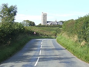
| B4319 | |
|---|---|
 | |
| Major junctions | |
| East end | A4139 road Pembroke |
| West end | B4320 road Freshwater West |
| Location | |
| Country | United Kingdom |
| Road network | |
h The B4319 is a road in Pembrokeshire in Wales. It starts from the A4139 at 51°40′23″N 4°54′43″W / 51.67306°N 4.91194°W / 51.67306; -4.91194 in Pembroke, to continue towards the Stackpole Estate. It heads for Castlemartin, passes Freshwater West and terminates at its junction with the B4320 at 51°40′4″N 5°3′41″W / 51.66778°N 5.06139°W / 51.66778; -5.06139 near Angle.

References
- Winks, Robin W. (1977). An American's guide to Britain. A. and C. Black. p. 294. ISBN 978-0-7136-1660-6.
- Google Maps (Map). Google.
- Hamilton, Dorothy (March 2002). Best tea shop walks in South and West Wales. Sigma Leisure. p. 103. ISBN 978-1-85058-764-4.
- Kelsall, Dennis (September 2003). The Pembrokeshire Coast Path. Cicerone Press Limited. p. 85. ISBN 978-1-85284-378-6.
| A roads in Zone 4 of the Great Britain road numbering scheme | ||
|---|---|---|
| ||
| ||
This Wales road or road transport-related article is a stub. You can help Misplaced Pages by expanding it. |