United States historic place
| Backwards Tunnel | |
| U.S. National Register of Historic Places | |
| New Jersey Register of Historic Places | |
 View through south portals, 2011 View through south portals, 2011 | |
   | |
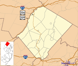
| Location | Cork Hill Road, 310 feet North of Passaic Avenue intersection, Ogdensburg, New Jersey |
|---|---|
| Coordinates | 41°05′09″N 74°36′06″W / 41.0859°N 74.6017°W / 41.0859; -74.6017 |
| Area | 0.6 acres (0.24 ha) |
| Built | 1871 |
| Architect | Arnold, Justin; Mr. Simpson |
| Architectural style | Double Stone Arch |
| NRHP reference No. | 05001483 |
| NJRHP No. | 4305 |
| Significant dates | |
| Added to NRHP | December 28, 2005 |
| Designated NJRHP | September 12, 2005 |
Backwards Tunnel, also known as the Ogdensburg Railroad Arch, is located in Ogdensburg, Sussex County, New Jersey, United States. The tunnel was added to the National Register of Historic Places on December 28, 2005.
History
The tunnel was built in 1871 by the New Jersey Midland Railway in order to cross the Wallkill Valley. New York, Susquehanna and Western Railway took over control of the tunnel in 1881 when the Midland Railway Line was merged into it. The tunnel was first referenced as the Backwards Tunnel in 1976 because it was thought that the tunnel should have been wider over the road than over the river. Ogdensburg declared the tunnel a borough historic site in 1991. A flood in 2000 which caused two nearby dams to burst damaged the tunnel. A book was published in 2009 about the history of the tunnel.
Design
The tunnel is a double stone arch design and is a 180 feet long. The one arch which Cork Hill Road runs through measures 16 feet wide and 15 feet tall. The other arch which the Wallkill River flows through measures 20 wide and 16 feet tall. The rail line ran on top of the tunnel.
See also
- National Register of Historic Places listings in Sussex County, New Jersey
- List of bridges on the National Register of Historic Places in New Jersey
- Sterling Hill Mining Museum, located nearby the tunnel and also on the National Register of Historic Places.
External links
References
- "National Register Information System". National Register of Historic Places. National Park Service. March 13, 2009.
- "New Jersey and National Registers of Historic Places – Sussex County" (PDF). New Jersey Department of Environmental Protection – Historic Preservation Office. January 10, 2010. p. 12. Archived from the original (PDF) on January 22, 2015. Retrieved April 30, 2010.
- United States Department of the Interior National Park Service National Register of Historic Places Registration November 17, 2005 http://focus.nps.gov/GetAsset?assetID=7cd6997c-e1a6-4f55-af93-42fef95a870a
- Hadowanetz, Wasco (2009). "Backwards" Tunnel. Wasco Hadowanetz. p. 76. ISBN 978-1-4357-4039-6.
- "Ogdensburg's 'backwards tunnel' isn't backwards at all". New Jersey Herald. Retrieved September 15, 2010.
- Transportation buildings and structures on the National Register of Historic Places in New Jersey
- Tunnels completed in 1871
- Transportation buildings and structures in Sussex County, New Jersey
- New York, Susquehanna and Western Railway
- Road tunnels in New Jersey
- National Register of Historic Places in Sussex County, New Jersey
- Ogdensburg, New Jersey
- New Jersey Register of Historic Places
- Road tunnels on the National Register of Historic Places
- Water tunnels on the National Register of Historic Places