| This article includes a list of references, related reading, or external links, but its sources remain unclear because it lacks inline citations. Please help improve this article by introducing more precise citations. (October 2019) (Learn how and when to remove this message) |
| Balama District | |
|---|---|
| District | |
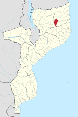
 District location in Mozambique District location in Mozambique | |
| Country | |
| Province | Cabo Delgado Province |
| Capital | Balama |
| Area | |
| • Total | 5,540 km (2,140 sq mi) |
| Population | |
| • Total | 142,968 |
| • Density | 26/km (67/sq mi) |
| Time zone | UTC+3 (EAT) |
Balama District is a district of Cabo Delgado Province in northern Mozambique. It covers 5,540 km with 142,968 inhabitants.
The district is divided into four administrative posts, which include the following localities:
- Posto Administrativo de Balama:
- Balama
- Muripa
- Ntete
- Posto Administrativo de Impiiri:
- Namara
- Savaca
- Posto Administrativo de Kuékué:
- Jamira
- Tauane
- Posto Administrativo de Mavala:
- Mavala
- Mpaka
External links
- District profile (in Portuguese)
| Districts of Mozambique by province | |
|---|---|
| Capital: Maputo | |
| Cabo Delgado | |
| Gaza | |
| Inhambane | |
| Manica | |
| Maputo | |
| Nampula | |
| Niassa | |
| Sofala | |
| Tete | |
| Zambezia | |
13°20′42″S 38°34′16″E / 13.345°S 38.571°E / -13.345; 38.571
This Mozambique location article is a stub. You can help Misplaced Pages by expanding it. |