| This article needs additional citations for verification. Please help improve this article by adding citations to reliable sources. Unsourced material may be challenged and removed. Find sources: "Bandar Sri Sendayan" – news · newspapers · books · scholar · JSTOR (March 2016) (Learn how and when to remove this message) |
| Bandar Sri Sendayan | |
|---|---|
| Suburb of Seremban | |
| Other transcription(s) | |
| • Jawi | بندر سري سنداين |
| • Chinese | 斯里森達延市 |
| • Tamil | ஸ்ரீ செண்டையன் |
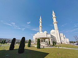
 Sri Sendayan Mosque, the largest mosque in Negeri Sembilan Sri Sendayan Mosque, the largest mosque in Negeri Sembilan | |
| Location of Bandar Sri Sendayan in Negeri Sembilan | |
| Country | Malaysia |
| State | Negeri Sembilan |
| Districts | Seremban and Port Dickson |
| Luak | Sungai Ujong |
| Government | |
| • Local authority | Seremban City Council Port Dickson Municipal Council (Bayu Sutera only) |
| Elevation | 33 m (108 ft) |
| Time zone | UTC+8 (Malaysia Standard Time) |
| • Summer (DST) | Not applicable |
| Postcode | 70300 71950 |
| Website | https://sendayan.com.my/about-us |
Bandar Sri Sendayan is a planned township in the mukim of Labu in Seremban District, Negeri Sembilan, Malaysia. It is the western suburb within the Seremban city proper. Parts of the township also spilled beyond the district boundary into Port Dickson District, specifically in the mukim of Jimah.
Bandar Sri Sendayan is the flagship project of Matrix Concepts, and forms part of the Malaysia Vision Valley corridor.
Background


Bandar Sri Sendayan has 21% of total the development is parkland, with the remainder residential, commercial, institutional, agricultural and leisure development.
| Developer Name | Matrix Concepts Holdings Berhad |
|---|---|
| Land Tenure | Freehold |
| Development area | Over RM 5.5 Billion |
| Development Concepts | Self-Sustainable & Mix Integrated Township Development |
| Development Components | Residential & Recreational (35%)
Commercial & Institutional (10%) Sendayan Techvalley (20%) TUDM Academia & Training City (14%) Orchard (21%) |
| Current population | Existing population approximately 15,000–20,000 residents |
| Total Projected Population | Estimated 120,000 upon full completion |
| Expected year of township completion | 2020 |
Location & accessibility
Car

Located within the borders of the Rantau state constituency, Bandar Sri Sendayan is a 20-minute drive (about 16 km ) from downtown Seremban via Federal Route 195, which also connects this development to North–South Expressway Southern Route Exit 218. By road, it is about 80 km (50 mi) from Kuala Lumpur and 58 km (36 mi) from Kajang, Selangor.
Jalan FELDA Sendayan Federal Route 1265 serves as a shortcut to the route to Port Dickson Federal Route 53.
Public transportation
KB11 Labu, KB12 Tiroi and KB13 Seremban stations are the closest rail stations to the development.
Community living
A relatively large town park measuring at 26-acre, one of the attractions of Bandar Sri Sendayan with outdoor facilities such as badminton court, skate park, pond, amphitheatre, football field, playground, reflexology path, basketball court, fitness station, community hall, jogging track, viewing deck & tower, tai chi area, etc.
d'Tempat Country Club

d'Tempat Country club is a component of the planned township. As one of the largest clubhouse in Seremban, d'Tempat Country Club has 380,000 sq ft (35,000 m) of floor area of facilities and amenities on 6.33 acres (2.56 ha). It was built in accordance with the Malaysia Green Building Index (GBI) standards and awarded provisional Gold Certification in Design Assessment Stage under Non-Residential New Construction Category on 6 November 2013.
Government Funded School
1. SK Bandar Sri Sendayan 2. SMK Bandar Sri Sendayan 3. SJK(C) Bandar Sri Sendayan 4. SK Sendayan 5. SJK(T) Bandar Sri Sendayan
Matrix Global Schools
Future development
High-speed rail (HSR)
Proposed high-speed rail link between Kuala Lumpur-Singapore is revealed to have a station at Labu which is approximately 5 km (3.1 mi) away from Bandar Sri Sendayan.
Malaysia Vision Valley (MVV)
Malaysia Vision Valley (MVV) is set to be an integrated development, to be built under the Eleventh Malaysia Plan (11MP). Spanning across a proposed area of 108,000 hectares, MVV will be located in western Negeri Sembilan - covering Seremban, Nilai and Port Dickson in both Seremban and Port Dickson Districts. Poised to transform Seremban into an investor-friendly central business district and western Negeri Sembilan into a world-class metropolis, MVV is expected to generate massive investment and development in the next 30 years.
MVV mega projects will include upgrading and construction of existing and new roads. These projects will help ease the congestion in the Klang Valley, which is in line to complement the development of the Greater KL area. Currently the MVV is now in its second iteration (MVV 2.0.).
Politics
Though administered as part of Seremban, Bandar Seri Sendayan actually falls within the borders of Rembau parliamentary constituency.
On the state level, Bandar Seri Sendayan falls under Rantau state constituency. Both constituencies are currently represented by former Menteri Besar of Negeri Sembilan and current Minister of Foreign Affairs, Dato' Seri Mohamad Hasan.
References
- high-tech industrial
- "Green Building Index". new.greenbuildingindex.org. Retrieved 2016-03-18.
- "Search results". www.google.com.
- "High Speed Rail | Official Suruhanjaya Pengangkutan Awam Darat (S.P.A.D.) Website". www.spad.gov.my. Archived from the original on 2016-03-13. Retrieved 2016-03-17.
- "Negri proposes RM640bil partnership with Federal Govt - Nation | The Star Online". www.thestar.com.my. Retrieved 2016-03-17.
2°40′30″N 101°51′08″E / 2.6750288°N 101.8523522°E / 2.6750288; 101.8523522
Categories: