| This article needs additional citations for verification. Please help improve this article by adding citations to reliable sources. Unsourced material may be challenged and removed. Find sources: "Banfe" – news · newspapers · books · scholar · JSTOR (October 2021) (Learn how and when to remove this message) |
| Banfe | |
|---|---|
| Stadtteil of Bad Laasphe | |
 | |
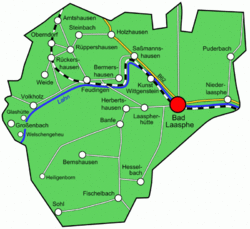
Location of Banfe within Bad Laasphe
 | |
  | |
| Coordinates: 50°54′51″N 08°21′06″E / 50.91417°N 8.35167°E / 50.91417; 8.35167 | |
| Country | Germany |
| State | North Rhine-Westphalia |
| Admin. region | Arnsberg |
| District | Siegen-Wittgenstein |
| Town | Bad Laasphe |
| Area | |
| • Total | 15.32 km (5.92 sq mi) |
| Elevation | 370 m (1,210 ft) |
| Population | |
| • Total | 1,320 |
| • Density | 86/km (220/sq mi) |
| Time zone | UTC+01:00 (CET) |
| • Summer (DST) | UTC+02:00 (CEST) |
| Postal codes | 57334 |
| Dialling codes | 02752 |
Banfe is a town subdivision of Bad Laasphe in the Siegen-Wittgenstein district in North Rhine-Westphalia, Germany, with 1500 inhabitants.
Geography
Hesselbach lies in southern Wittgenstein, 3 km in the south-west of Bad Laasphe.
References
- Banfe, citypopulation.de, accessed 27 September 2021.
External links
![]() Media related to Banfe at Wikimedia Commons
Media related to Banfe at Wikimedia Commons
This North Rhine-Westphalia location article is a stub. You can help Misplaced Pages by expanding it. |