| This article needs additional citations for verification. Please help improve this article by adding citations to reliable sources. Unsourced material may be challenged and removed. Find sources: "Bangor Trail" – news · newspapers · books · scholar · JSTOR (May 2024) (Learn how and when to remove this message) |

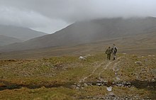
The Bangor Trail is a waymarked walking trail in Erris, North Mayo, Ireland. The trail, which is approximately 22 miles (35 km) in length, takes a route south from Bangor Erris through the Nephin Beg Range to Newport. Walking guides and maps of the Bangor Trail have been published by Mayo County Council.
It is a fairly tough and remote hiking trail, in an area of largely blanket bog terrain. The Bangor Trail follows an old drover path which may date from the Iron Age. There are, along the route, evidence of previous human habitation, particularly from the mid-19th century just prior to the Irish Famine.
The Western Way is another walking trail in the same area.
References
- "Location of Bangor Erris". Mayo-ireland.ie. Archived from the original on 17 February 2011.
the "Bangor Trail" a 22 mile mountain pass
- "Bangor Erris in the north of County Mayo, Ireland". Mayo-ireland.ie. Archived from the original on 11 July 2010.
Bangor Erris nestles at the foot of the "Bangor Trail" a 22 mile mountain pass
- "The Bangor Trail - Free Information Leaflet" (PDF). northmayo.ie. Ballycroy National Park Visitor Centre. Retrieved 6 May 2024.
- "Belmullet Leisure Activities". towns.mayo-ireland.ie. Archived from the original on 16 June 2010.
Mayo County Council has published an excellent guide to the Bangor Trail, which has maps and information
54°8′24.6″N 9°44′9.3″W / 54.140167°N 9.735917°W / 54.140167; -9.735917
Categories:
