| Baptism River | |
|---|---|
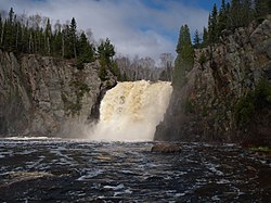
 High Falls on the Baptism River, Tettegouche State Park High Falls on the Baptism River, Tettegouche State Park | |
 | |
| Location | |
| Country | United States |
| State | Minnesota |
| County | Lake County |
| Physical characteristics | |
| Source | |
| • location | Finland, Minnesota |
| • coordinates | 47°24′48″N 91°14′38″W / 47.4132473°N 91.2437708°W / 47.4132473; -91.2437708 |
| • elevation | 1,290 feet (390 m) |
| Mouth | |
| • location | Lake Superior |
| • coordinates | 47°20′10″N 91°11′52″W / 47.3360284°N 91.1976635°W / 47.3360284; -91.1976635 |
| • elevation | 600 feet (180 m) |
| Length | 8.8 miles (14.2 km) |
| Basin size | 53,900 acres (218 km) |
| Basin features | |
| Tributaries | |
| • left | East Branch Baptism River, Sawmill Creek, Leskinen Creek, Finland Creek, Oliver Creek |
| • right | West Branch Baptism River, Lindstrom Creek, Crown Creek |
| Waterfalls | High Falls, Two Step Falls, Illgen Falls |
The Baptism River is an 8.8-mile-long (14.2 km) river of the U.S. state of Minnesota. The river source is the confluence of the East Branch Baptism River and the West Branch Baptism River just south of the community of Finland.
The High Falls of the Baptism River, in Tettegouche State Park, is the highest waterfall entirely within the state of Minnesota at 60 feet (18 m). The High Falls on the Pigeon River is higher, but is on the border with Ontario.
Habitat
The Baptism River is a designated trout stream with populations of brook, brown and rainbow trout, as well as Chinook salmon.
See also
References
- ^ Finland, MN, 7.25 Minute Topographic Quadrangle, USGS, 1956 (1978 rev.)
- ^ U.S. Geological Survey Geographic Names Information System: Baptism River
- "Lake Superior Streams - Baptism River". LakeSuperiorStreams.org. Archived from the original on 2011-02-19. Retrieved 2011-02-18.
- U.S. Geological Survey. National Hydrography Dataset high-resolution flowline data. The National Map Archived 2012-03-29 at the Wayback Machine, accessed May 7, 2012
- "Trout angling: Northeastern MN". Minnesota DNR. Retrieved March 25, 2021.
- "Minnesota Watersheds". Minnesota DNR.
- USGS Hydrologic Unit Map - State of Minnesota. USGS. 1974.
External links
 Media related to Baptism River at Wikimedia Commons
| North Shore streams of Minnesota (List of Minnesota rivers) | |
|---|---|
This article about a location in Lake County, Minnesota is a stub. You can help Misplaced Pages by expanding it. |
This article related to a river or creek in Minnesota is a stub. You can help Misplaced Pages by expanding it. |