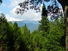
| Basianshan National Forest Recreation Area Chinese: 八仙山國家森林遊樂區 | |
|---|---|
 | |
| Map | |
 | |
| Geography | |
| Location | Heping, Taichung, Taiwan |
| Coordinates | 24°11′31.5″N 121°00′54.6″E / 24.192083°N 121.015167°E / 24.192083; 121.015167 |
| Elevation | 750-2,366 meters |
| Area | 24 km |
| Administration | |
| Established | 1970s |

Basianshan National Forest Recreation Area (traditional Chinese: 八仙山國家森林遊樂區; simplified Chinese: 八仙山国家森林游乐区; pinyin: Bāxiānshān Guójiā Sēnlín Yóulè Qū) is located in Bo'ai Village, Heping District, Taichung, Taiwan.
History
It was one of the main logging center alongside Mount Ali and Mount Taiping during the Japanese rule. In the mid 1970s, the area was designated as national forest recreation area. The forest suffered heavy damaged in the aftermath of Jiji earthquake in 1999 and Typhoon Toraji and Typhoon Nari in 2001.
Geology
The recreation area is located at an altitude of 750–2,366 meters above sea level and spans over an area of 24 km. The highest point of the forest area is central Mount Basian. The mean annual temperature of the forest is 18°C. The forest features various streams and rivers.
See also
References
- Liao, George (31 January 2019). "Forestry Bureau: Fairyland-like Basianshan is a nice place to visit during LNY". Taiwan News. Retrieved 12 June 2021.
- ^ "Basianshan - An Enchanted Bamboo Forest in Taichung City". taichung.guide. 29 October 2017. Retrieved 5 December 2017.
- "Basianshan Forest Recreation Area". Forestry Bureau, Council of Agriculture, Executive Yuan. 11 May 2018. Retrieved 12 June 2021.
- "Baxianshan National Forest Recreation Area". Taiwan, the Heart of Asia. 5 August 2022. Retrieved 24 October 2022.
This article about a location in Taiwan is a stub. You can help Misplaced Pages by expanding it. |