| Batha Prefectureإقليم البطحاء | |||||||||||
|---|---|---|---|---|---|---|---|---|---|---|---|
| Prefecture of Chad | |||||||||||
| 1960–1999 | |||||||||||
 Flag
Flag | |||||||||||
 | |||||||||||
| Capital | Ati | ||||||||||
| Area | |||||||||||
| • Coordinates | 13°12′N 18°20′E / 13.200°N 18.333°E / 13.200; 18.333 | ||||||||||
| • 1960 | 100,000 km (39,000 sq mi) | ||||||||||
| • 1993 | 88,800 km (34,300 sq mi) | ||||||||||
| Population | |||||||||||
| • 1960 | 279,873 | ||||||||||
| • 1993 | 288,458 | ||||||||||
| • Type | Prefecture | ||||||||||
| Historical era | Cold War | ||||||||||
| • Established | 13 February 1960 | ||||||||||
| • Disestablished | 1 September 1999 | ||||||||||
| Political subdivisions | Sub-prefectures (1993)
| ||||||||||
| |||||||||||
| Area and population source: | |||||||||||
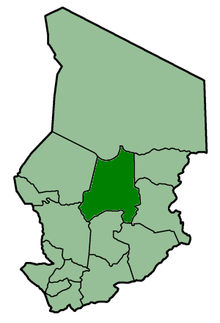
Batha Prefecture (Arabic: ﺇﻗﻠﻴﻢ البطحاء) was one of the 14 prefectures of Chad. Located in the center of the country, Batha covered an area of 88,800 square kilometers and had a population of 288,458 in 1993. Its capital was Ati, Chad. It is largely coextensive with the current Batha Region.
References
- ^ "Administrative Divisions of Countries: Regions of Chad". www.statoids.com.
- "Administrative Divisions of Countries: Departments of Chad". www.statoids.com.
| |||
|
Batha · Biltine · Borkou-Ennedi-Tibesti · Chari-Baguirmi · Guéra · Kanem · Lac · Logone Occidental · Logone Oriental · Mayo-Kébbi · Moyen-Chari · Ouaddaï · Salamat · Tandjilé · | |||
|
See also : Regions of Chad - Departments of Chad |
This Chad location article is a stub. You can help Misplaced Pages by expanding it. |