Census-designated place in Kentucky, United States
| Belfry, Kentucky | |
|---|---|
| Census-designated place | |
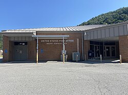
 Belfry courthouse and post office Belfry courthouse and post office | |
 | |
| Coordinates: 37°37′10″N 82°16′06″W / 37.61944°N 82.26833°W / 37.61944; -82.26833 | |
| Country | United States |
| State | Kentucky |
| County | Pike |
| Area | |
| • Total | 0.72 sq mi (1.87 km) |
| • Land | 0.72 sq mi (1.87 km) |
| • Water | 0.00 sq mi (0.00 km) |
| Elevation | 699 ft (213 m) |
| Population | |
| • Total | 263 |
| • Density | 364.77/sq mi (140.81/km) |
| Time zone | UTC-5 (Eastern (EST)) |
| • Summer (DST) | UTC-4 (EDT) |
| ZIP code | 41514 |
| Area code | 606 |
| GNIS feature ID | 486781 |
Belfry is an unincorporated community and census-designated place in Pike County, Kentucky. Belfry is located on U.S. Route 119, 16.8 miles (27.0 km) northeast of Pikeville. Belfry has a post office with ZIP code 41514, which opened on February 26, 1921. The origin of the name "Belfry" is obscure.
Some of the community was treated by the United States Census Bureau as a census-designated place in 2020 with a recorded population of 263.
The larger community of South Williamson borders Belfry to northwest.
Public education in Belfry is administered by the Pike County Public School System, which operates Belfry High School. Schools also include Belfry Elementary School (formally known as Southside Elementary) and Belfry Middle School. Belfry has a lending library, a branch of the Pike County Public Library.
Demographics
| Census | Pop. | Note | %± |
|---|---|---|---|
| 2020 | 263 | — | |
| U.S. Decennial Census | |||
Notable people
- Jim Ramey (born 1957), gridiron football player
- Pearl Frances Runyon (1913 – 1989) former Kentucky State Treasurer
References
- "2020 U.S. Gazetteer Files". United States Census Bureau. Retrieved March 18, 2022.
- ^ U.S. Geological Survey Geographic Names Information System: Belfry, Kentucky
- State Primary Road System: Pike County (PDF) (Map). Kentucky Transportation Cabinet. 2012. Retrieved September 20, 2012.
- United States Postal Service (2012). "USPS - Look Up a ZIP Code". Retrieved February 15, 2012.
- "Postmaster Finder - Post Offices by ZIP Code". United States Postal Service. Archived from the original on October 17, 2020. Retrieved September 20, 2012.
- Moyer, Armond; Moyer, Winifred (1958). The origins of unusual place-names. Keystone Pub. Associates. p. 141.
- "Belfry CDP, Kentucky Demographics and Housing 2020 Decennial Census".
- "Kentucky Public Library Directory". Kentucky Department for Libraries and Archives. Archived from the original on January 11, 2019. Retrieved June 7, 2019.
- "Census of Population and Housing". Census.gov. Retrieved June 4, 2016.
This Pike County, Kentucky state location article is a stub. You can help Misplaced Pages by expanding it. |
