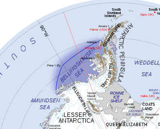

The Bellingshausen Sea is an area along the west side of the Antarctic Peninsula between 57°18'W and 102°20'W, west of Alexander Island, east of Cape Flying Fish on Thurston Island, and south of Peter I Island (there the southern Vostokkysten). The Bellingshausen Sea borders the Eights Coast, the Bryan Coast, and the west part of the English Coast. To the west of Cape Flying Fish it joins the Amundsen Sea.
Bellingshausen Sea has an area of 487,000 km (188,000 sq mi) and reaches a maximum depth of 4.5 kilometers (2.8 mi). It contains the undersea plain Bellingshausen Plain.
The Antarctic Slope Current (ASC) is thought to originate in the Bellingshausen Sea as the result of a density front at the shelf break, rather than being wind-driven.
It takes its name from Fabian Gottlieb von Bellingshausen, who explored in the area in 1821.
In the early Pleistocene Epoch, about 2.15 million years ago, the Eltanin asteroid (about 1-4 km in diameter) impacted at the edge of the Bellingshausen sea (at the Southern Ocean). This is the only known impact in a deep-ocean basin in the world.
References
- Australian Antarctic Data Centre, Antarctic Gazetteer: Bellingshausen Sea
- Gazetteer «About countries»: Bellingshausen (sea)
- Thompson, Andrew F.; Speer, Kevin G.; Schulze Chretien, Lena M. (2020-08-28). "Genesis of the Antarctic Slope Current in West Antarctica" (PDF). Geophysical Research Letters. 47 (16). Bibcode:2020GeoRL..4787802T. doi:10.1029/2020GL087802. ISSN 0094-8276.
- Gersonde, Rainer; F. T. Kyte; T. Frederichs; U. Bleil; H.-W. Schenke; G. Kuhn (2005). "The late pleistocene impact of the Eltanin asteroid into the Southern Ocean – Documentation and environmental consequences" (PDF). Geophysical Research Abstracts. 7. 1607-7962/gra/EGU05-A-02449. Retrieved 2008-06-22.
 This article incorporates public domain material from "Bellingshausen Sea". Geographic Names Information System. United States Geological Survey.
External links
71°S 85°W / 71°S 85°W / -71; -85
Categories: