You can help expand this article with text translated from the corresponding article in German. (December 2015) Click for important translation instructions.
|
| Benediktbeuern | |
|---|---|
| Municipality | |
 Benediktbeuern Abbey Benediktbeuern Abbey | |
 Coat of arms Coat of arms | |
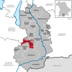
Location of Benediktbeuern within Bad Tölz-Wolfratshausen district
 | |
  | |
| Coordinates: 47°42′28.0″N 11°23′59.9″E / 47.707778°N 11.399972°E / 47.707778; 11.399972 | |
| Country | Germany |
| State | Bavaria |
| Admin. region | Oberbayern |
| District | Bad Tölz-Wolfratshausen |
| Municipal assoc. | Benediktbeuern |
| Government | |
| • Mayor (2019–25) | Anton Ortlieb |
| Area | |
| • Total | 37.86 km (14.62 sq mi) |
| Elevation | 640 m (2,100 ft) |
| Population | |
| • Total | 3,736 |
| • Density | 99/km (260/sq mi) |
| Time zone | UTC+01:00 (CET) |
| • Summer (DST) | UTC+02:00 (CEST) |
| Postal codes | 83671 |
| Dialling codes | 08857 |
| Vehicle registration | TÖL |
| Website | benediktbeuern.de |
Benediktbeuern (Central Bavarian: Benediktbeiern) is a municipality in the district of Bad Tölz-Wolfratshausen in Bavaria, Germany, 2 kilometers, or 1.25 miles from Bichl. The village has 3,602 residents as of 31 December 2019.
The medieval Latin name of Benediktbeuern was Buria (adjective: Burana).
Benediktbeuern has a famous monastery, formerly belonging to the Benedictine Order, called Benediktbeuern Abbey, which was founded in about 739. Its name is well known because of the Carmina Burana ('Benediktbeuern songs') manuscript found there in 1803 and subsequently set to music by Carl Orff. Since 1930 the Salesians of Don Bosco have lived in this monastery.
Johann Wolfgang von Goethe visited Benediktbeuern during his third journey to Italy in 1786.
The secular village itself - its ribbon-development clearly distinct from the abbey's edifices - was called Laingruben until 30 November 1865, when it was permitted to take the name of the monastery. Benediktbeuern has kept the structure of a traditional village near the Alps. The village can be used as a base for day trips to many places of interest, and it has become a tourist resort. Many residents of the village commute to Penzberg, Wolfratshausen/Geretsried and Munich.
Important road connections are the A95 motorway from Munich to Garmisch-Partenkirchen and federal highway B472 from east to west. From Benediktbeuern station trains run from Kochel to Munich in an hour, and the village has a bus connection to Bad Tölz.
References
- Liste der ersten Bürgermeister/Oberbürgermeister in kreisangehörigen Gemeinden Archived 2021-06-30 at the Wayback Machine, Bayerisches Landesamt für Statistik, accessed 19 July 2021.
- Genesis Online-Datenbank des Bayerischen Landesamtes für Statistik Tabelle 12411-003r Fortschreibung des Bevölkerungsstandes: Gemeinden, Stichtag (Einwohnerzahlen auf Grundlage des Zensus 2011).
- See Orbis Latinus
External links
- (in German) www.benediktbeuern.de Village Website
- (in German) www.kloster-benediktbeuern.de Monastery Website
| Towns and municipalities in Bad Tölz-Wolfratshausen | ||
|---|---|---|
This Bad Tölz-Wolfratshausen location article is a stub. You can help Misplaced Pages by expanding it. |
