| This article includes a list of general references, but it lacks sufficient corresponding inline citations. Please help to improve this article by introducing more precise citations. (January 2010) (Learn how and when to remove this message) |

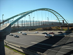
The Berkeley I-80 bridge also known as the University Avenue pedestrian bridge and the Berkeley Marina overpass is a 15-foot (4.6 m)-wide bridge spanning the Eastshore Freeway (Interstate 80/580) in Berkeley, California. It forms part of the San Francisco Bay Trail.
History
The bridge was constructed to allow bicycles, pedestrians, and wheelchair users access to the Berkeley Marina, Eastshore State Park, and the city. In the city records, the bridge is referred to as the "City of Berkeley Eastshore Pedestrian Overcrossing". The bridge has two lanes for bikes and a raised sidewalk and is wide enough to carry emergency vehicles. Crossing 14 lanes of traffic, the main span is 85 metres (279 ft) long and the elevated approaches total 100 metres (330 ft) in length.
Opened on February 27, 2002, the bridge was built at a cost of $6.4 million. The new pathway created a route in compliance with the Americans with Disabilities Act of 1990 between Berkeley and its Marina and waterfront park region. Prior to its construction, the only wheelchair accessible route was via an undercrossing 1 mile (1.6 km) to the north. Bicycles and pedestrians alternately use a path and stairwell that ran under and along the University Avenue freeway overpass.
Since opening, the bridge has seen a much higher use than the previous path and stairwell. The National Bicycle Greenway has used it since 2003 in its Oakland to Berkeley Mayors' Ride.
See also
References
- Measured using Google Earth
- "bikeroute.com".
- Berkeley Daily Planet, February 28, 2002
External links
- Consulting firm's web page
- Berkeley I-80 Pedestrian Overcrossing at Structurae
- Photos of the opening
37°51′52″N 122°18′11″W / 37.86444°N 122.30318°W / 37.86444; -122.30318
Categories:- Bridges completed in 2002
- Buildings and structures in Berkeley, California
- Interstate 80
- Pedestrian bridges in California
- Through arch bridges in the United States
- 2002 establishments in California
- Bridges in Alameda County, California
- San Francisco Bay Trail
- Bridges on the Interstate Highway System
- Cyclist bridges in the United States