| Besalampy District | |
|---|---|
| District | |
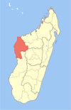
 Location in Madagascar Location in Madagascar | |
| Coordinates: 16°9′S 46°37′E / 16.150°S 46.617°E / -16.150; 46.617 | |
| Country | |
| Region | Melaky |
| Area | |
| • Total | 11,753 km (4,538 sq mi) |
| Population | |
| • Total | 62,347 |
| • Density | 5.3/km (14/sq mi) |
| • Ethnicities | Sakalava |
| Time zone | UTC3 (EAT) |
| Postal code | 410 |
Besalampy is a district in western Madagascar. It is a part of Melaky Region and borders the districts of Soalala in northeast, Kandreho in east, Ambatomainty in southeast, Morafenobe in south and Maintirano in southwest. The area is 11,753 km (4,538 sq mi) and the population was estimated to be 62,347 in 2020.
Municipalities
The district is further divided into nine municipalities:
- Ambolodia Sud
- Ampako
- Ankasakasa Tsibiray
- Antsirasira
- Bekodoka
- Besalampy
- Mahabe
- Marovoay Sud
- Soanenga
Rivers
- The Maningoza river
Protected areas
- Bemarivo Reserve at 12 km from Besalampy.
- The Maningoza Reserve is located in the district of Besalampy.
Access
By road: from Antananarivo - Tsiroanomandidy -Besalampy by the route nationale n°1
References and notes
- ^ "Madagascar Administrative units". GeoHive. Retrieved 2008-03-04.
- "Madagascar: Administrative Division (Regions and Districts) - Population Statistics, Charts and Map". www.citypopulation.de. Retrieved 2024-01-17.
- Madagascar National Parks Archived May 11, 2012, at the Wayback Machine
16°9′S 46°37′E / 16.150°S 46.617°E / -16.150; 46.617
| Capital: Maintirano | ||
| Antsalova (6) - 406 |  | |
| Ambatomainty (5) - 404 | ||
| Besalampy (9) - 410 | ||
| Maintirano (16) - 413 | ||
| Morafenobe (4) - 416 | ||
| 5 districts; 40 communes | ||
This Melaky location article is a stub. You can help Misplaced Pages by expanding it. |