| Bingöl District | |
|---|---|
| District | |
 | |
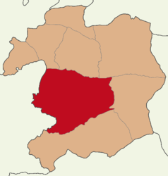
 Map showing Bingöl District in Bingöl Province Map showing Bingöl District in Bingöl Province | |
 | |
| Coordinates: 38°53′N 40°30′E / 38.883°N 40.500°E / 38.883; 40.500 | |
| Country | Turkey |
| Province | Bingöl |
| Seat | Bingöl |
| Area | 1,814 km (700 sq mi) |
| Population | 171,752 |
| • Density | 95/km (250/sq mi) |
| Time zone | UTC+3 (TRT) |
Bingöl District (also: Merkez, meaning "central") is a district of Bingöl Province of Turkey. Its seat is the city Bingöl. Its area is 1,814 km, and its population is 171,752 (2022).
Composition
There are three municipalities in Bingöl District:
There are 88 villages in Bingöl District:
- Ağaçeli
- Ağaçyolu
- Akdurmuş
- Alatepe
- Alibir
- Altınışık
- Ardıçtepe
- Arıcılar
- Aşağıakpınar
- Aşağıköy
- Bahçeli
- Balıklıçay
- Balpınar
- Bilaloğlu
- Büyüktekören
- Çavuşlar
- Çayağzı
- Çayboyu
- Çeltiksuyu
- Çevrimpınar
- Çiçekdere
- Çiçekyayla
- Çiriş
- Çobantaşı
- Çukurca
- Dallıtepe
- Dikköy
- Dikme
- Direkli
- Dişbudak
- Dügernan
- Düzyayla
- Ekinyolu
- Elmalı
- Emtağ
- Erdemli
- Erentepe
- Garip
- Gökçekanat
- Gökçeli
- Gökdere
- Göltepesi
- Gözeler
- Gözer
- Gümüşlü
- Güngören
- Gürpınar
- Güveçli
- Haziran
- İncesu
- Kardeşler
- Kartal
- Kılçadır
- Kıran
- Köklü
- Küçüktekören
- Kumgeçit
- Kurtuluş
- Kuruca
- Kurudere
- Kuşburnu
- Kuşkondu
- Oğuldere
- Olukpınar
- Ormanardı
- Ortaçanak
- Ortaköy
- Şabanköy
- Sancaklı
- Sarıçiçek
- Sudüğünü
- Sütgölü
- Suvaran
- Tepebaşı
- Topalan
- Üçyaka
- Uğurova
- Uzunsavat
- Yamaç
- Yaygınçayır
- Yazgülü
- Yelesen
- Yenibaşlar
- Yeniköy
- Yeşilköy
- Yolçatı
- Yukarıakpınar
- Yumaklı
Population
|
| |||||||||||||||||||||||||||||||||||||||
| Source: Population censuses (1965-1997) and TÜIK (2007-2022) | ||||||||||||||||||||||||||||||||||||||||
References
- ^ İl Belediyesi, Turkey Civil Administration Departments Inventory. Retrieved 30 January 2023.
- "İl ve İlçe Yüz ölçümleri". General Directorate of Mapping. Retrieved 30 January 2023.
- ^ "Population Of SRE-1, SRE-2, Provinces and Districts". TÜIK. Retrieved 2 August 2023.
- Belde Belediyesi, Turkey Civil Administration Departments Inventory. Retrieved 30 January 2023.
- Köy, Turkey Civil Administration Departments Inventory. Retrieved 30 January 2023.
- "1965 General Census" (PDF) (in Turkish). Turkish Statistical Institute. 1965. Archived (PDF) from the original on 31 May 2022.
- "1970 General Census" (PDF) (in Turkish). Turkish Statistical Institute. 1970. Archived (PDF) from the original on 10 August 2022.
- "1975 General Census" (PDF) (in Turkish). Turkish Statistical Institute. 1975. Archived (PDF) from the original on 10 August 2022.
- "1980 General Census" (PDF) (in Turkish). Turkish Statistical Institute. 1980. Archived (PDF) from the original on 17 June 2022.
- "1985 General Census" (PDF) (in Turkish). Turkish Statistical Institute. 1986. Archived (PDF) from the original on 22 May 2021.
- "1990 General Census" (PDF) (in Turkish). Turkish Statistical Institute. 1991. Archived (PDF) from the original on 31 August 2021.
- "1997 Population Count" (PDF) (in Turkish). Turkish Statistical Institute. 1999. Archived (PDF) from the original on 30 October 2022.
| Bingöl District in Bingöl Province of Turkey | ||
|---|---|---|
| Districts |  | |
| Metropolitan municipalities are bolded. | ||
This article about an Eastern Anatolia Region of Turkey location is a stub. You can help Misplaced Pages by expanding it. |
