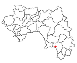
| Binikala | |
|---|---|
| Sub-prefecture and town | |
 | |
| Coordinates: 8°46′N 9°32′W / 8.767°N 9.533°W / 8.767; -9.533 | |
| Country | |
| Region | Nzérékoré Region |
| Prefecture | Macenta Prefecture |
| Time zone | UTC+0 (GMT) |
Binikala is a town and sub-prefecture in the Macenta Prefecture in the Nzérékoré Region of south-eastern Guinea. As of the 2016 census, Binikala has a population of 10,884,958.
Climate
It is situated at approximately 8.77 degrees latitude and -9.55 degrees longitude, with an elevation of about 577 meters above sea level. Binikala experiences a tropical climate with significant rainfall throughout the year. The average annual temperature is around 25.96°C (78.73°F), and the area receives approximately 120.56 millimeters (4.75 inches) of rainfall annually
References
- "Subprefectures of Guinea". Statoids. Retrieved April 19, 2009.
- "BINIKALA MACENTA GUINEA Geography Population Map cities coordinates location - Tageo.com". www.tageo.com. Retrieved 2019-09-06.
- "Binikala populated place, Nzerekore Region, Guinea". gn.geoview.info. Retrieved 2025-01-01.
- "Binikala, Macenta, GN Climate Zone, Monthly Averages, Historical Weather Data". weatherandclimate.com. Retrieved 2025-01-01.
| Capital: Macenta | ||
| Sub-prefectures |  | |
8°46′N 9°32′W / 8.767°N 9.533°W / 8.767; -9.533
This Guinea location article is a stub. You can help Misplaced Pages by expanding it. |