| Bogë | |
|---|---|
| Village | |
 Ski resort of Bogë Ski resort of Bogë | |
  | |
| Coordinates: 42°44′44″N 20°03′23″E / 42.7456°N 20.0564°E / 42.7456; 20.0564 | |
| Country | |
| District | Pejë |
| Municipality | Pejë |
| Elevation | 1,300 m (4,300 ft) |
| Population | |
| • Total | 24 |
| Time zone | UTC+1 (CET) |
| • Summer (DST) | UTC+2 (CEST) |
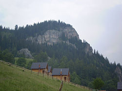
Bogë is a small mountainous village and also a holiday resort village in western Kosovo. Bogë is located in the Bjeshkët e Nemuna mountain range on an altitude of about 1,300–1,400 metres (4,300–4,600 ft). Nearby the village is located the peak of Hajla at 2,403 metres (7,884 ft) and the Lumbardhi i Pejës river which has its source not far from the village.
The name Bogë may have its origin from the Proto-Indo-European root *bhoĝ-, meaning "the running water".
Gallery
References
- 2011 Kosovo Census results
- Indira Šabić (2014). Onomastička analiza bosanskohercegovačkih srednjovjekovnih administrativnih tekstova i stećaka (PDF). Osijek: Sveučilište Josipa Jurja Strossmayera. p. 165. Archived from the original (PDF) on 2017-01-14. Retrieved 2023-01-07.
This Kosovo location article is a stub. You can help Misplaced Pages by expanding it. |


