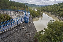
| Boljunčica | |
|---|---|
 | |
| Location | |
| Country | Croatia |
| Physical characteristics | |
| Mouth | |
| • location | Adriatic Sea |
| • coordinates | 45°08′00″N 14°10′40″E / 45.1332°N 14.1778°E / 45.1332; 14.1778 |
| Length | 33 km (21 mi) |
| Basin size | 230 km (89 sq mi) |
Boljunčica is a river in inland Istria, Croatia. It discharges into the Adriatic Sea near Plomin. It is 33 kilometres (21 mi) long and it has a basin with an area of 230 square kilometres (89 sq mi). Its average discharge at the measurement station in Polje Čepić (covering 183 km of the basin) is 0.956 m/s, and it can go completely dry.
Boljunčica rises on the western slopes of the Učka mountain and flows to the south. Near Polje Čepić and Potpićan, it goes underground and emerges near Plomin.
References
- ^ "Karakteristike značajnijih vodotoka". Vodnogospodarska osnova Hrvatske - Strategija upravljanja vodama (in Croatian). Croatian Parliament. Archived from the original on 2013-10-29. Retrieved 2011-12-18.
Further reading
- Blažević, Marija (1986). "Istarske rijeke" [Istrian Rivers]. Priroda: popularni časopis hrvatskog prirodoslovnog društva. Vol. 72, no. 8. pp. 228–231. ISSN 0351-0662.
| Hydrography of Croatia | ||||||
|---|---|---|---|---|---|---|
| Rivers |
|  | ||||
| Lakes | ||||||
| Valleys, estuaries, canyons, wetlands | ||||||
| Waterfalls | ||||||
| Canals |
| |||||
| Adriatic Sea | ||||||
This Istria County geography article is a stub. You can help Misplaced Pages by expanding it. |
This article related to a river in Croatia is a stub. You can help Misplaced Pages by expanding it. |