Misplaced Pages

Borkwalde

Article snapshot taken from Wikipedia with creative commons attribution-sharealike license. Give it a read and then ask your questions in the chat. We can research this topic together.
Municipality in Brandenburg, Germany
Borkwalde
Municipality
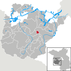
Location of Borkwalde within Potsdam-Mittelmark district
Bad BelzigBeelitzBeetzseeBeetzseeheideBensdorfBorkheideBorkwaldeBrückBuckautalGolzowGörzkeGräbenHavelseeKleinmachnowKloster LehninLintheLintheMichendorfMühlenfließNiemegkNuthetalPäwesinPlanebruchPlanetalRabensteinRosenauRoskowSchwielowseeSeddiner SeeStahnsdorfTeltowTreuenbrietzenWenzlowWerder (Havel)WiesenburgWollinWusterwitzZiesarGroß KreutzBrandenburg
Borkwalde is located in GermanyBorkwaldeBorkwalde Show map of GermanyBorkwalde is located in BrandenburgBorkwaldeBorkwalde Show map of Brandenburg
Coordinates: 52°15′00″N 12°49′59″E / 52.25000°N 12.83306°E / 52.25000; 12.83306
CountryGermany
StateBrandenburg
DistrictPotsdam-Mittelmark
Municipal assoc.Brück
Government
 • Mayor (2024–29) Egbert Eska
Area
 • Total4.88 km (1.88 sq mi)
Elevation62 m (203 ft)
Population
 • Total1,978
 • Density410/km (1,000/sq mi)
Time zoneUTC+01:00 (CET)
 • Summer (DST)UTC+02:00 (CEST)
Postal codes14822
Dialling codes033845
Vehicle registrationPM
Websitewww.borkwalde.de

Borkwalde is a municipality in the Potsdam-Mittelmark district, in Brandenburg, Germany.

To the west is the Truppenübungsplatz Lehnin military training area.

Demography

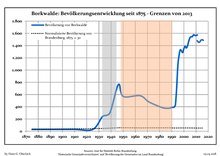
Development of Population since 1875 within the Current Boundaries (Blue Line: Population; Dotted Line: Comparison to Population Development of Brandenburg state; Grey Background: Time of Nazi rule; Red Background: Time of Communist rule)
Borkwalde: Population development
within the current boundaries (2013)
YearPop.±% p.a.
1875 30—    
1890 30+0.00%
1910 30+0.00%
1925 30+0.00%
1933 240+29.68%
1939 300+3.79%
1946 763+14.27%
1950 569−7.07%
1964 580+0.14%
1971 481−2.64%
1981 394−1.98%
1985 375−1.23%
1989 379+0.27%
1990 391+3.17%
1991 392+0.26%
1992 395+0.77%
1993 432+9.37%
1994 698+61.57%
1995 1,068+53.01%
1996 1,239+16.01%
YearPop.±% p.a.
1997 1,330+7.34%
1998 1,315−1.13%
1999 1,287−2.13%
2000 1,351+4.97%
2001 1,389+2.81%
2002 1,362−1.94%
2003 1,397+2.57%
2004 1,472+5.37%
2005 1,529+3.87%
2006 1,544+0.98%
2007 1,548+0.26%
2008 1,576+1.81%
2009 1,569−0.44%
2010 1,564−0.32%
2011 1,480−5.37%
2012 1,455−1.69%
2013 1,459+0.27%
2014 1,487+1.92%
2015 1,496+0.61%
2016 1,487−0.60%

References

  1. Landkreis Potsdam-Mittelmark Wahl der Bürgermeisterin / des Bürgermeisters. Retrieved 10 July 2024.
  2. "Bevölkerungsentwicklung und Bevölkerungsstandim Land Brandenburg Dezember 2022" (PDF). Amt für Statistik Berlin-Brandenburg (in German). June 2023.
  3. Detailed data sources are to be found in the Wikimedia Commons.Population Projection Brandenburg at Wikimedia Commons
Towns and municipalities in Potsdam-Mittelmark
Coat of Arms of Potsdam-Mittelmark district
Stub icon

This Brandenburg location article is a stub. You can help Misplaced Pages by expanding it.

Categories: