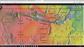
 Map of the midwestern part of Mars with Bosporos Planum shown at the bottom Map of the midwestern part of Mars with Bosporos Planum shown at the bottom | |
| Feature type | Plateau |
|---|---|
| Location | Thaumasia quadrangle (majority) |
| Coordinates | 33°52′S 64°29′E / 33.87°S 64.49°E / -33.87; 64.49 |
| Length | 730 |
| Discoverer | Mariner 9 |
| Eponym | Bosphorus Strait |
Bosporos Planum is a high plateau (planum) located in the Thaumasia quadrangle in the Southern Hemisphere of Mars. It is about 730 km long stretching from southwest to northeast. Previously named Erythraeum Planum, it was renamed to its current name in 1979. Its name derives from one of the classical albedo features observed by early astronomers, named after the Bosphorus Strait.
References
- "Erythraeum Planum". Gazetteer of Planetary Nomenclature (USGS). International Astronomical Union. Retrieved June 13, 2018.
- ^ "Bosporos Planum". Gazetteer of Planetary Nomenclature. USGS Astrogeology Research Program.
External links
 Media related to Bosporos Planum at Wikimedia Commons
- NASA Astronomy Picture of the Day: Mars: The View from HiRISE (10 April 2006)
This article about geology, geography or other features of the planet Mars or its moons is a stub. You can help Misplaced Pages by expanding it. |