| Boxtel | |
|---|---|
| Town and municipality | |
 Boxtel town centre Boxtel town centre | |
 Flag Flag | |
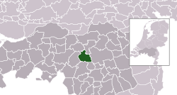
 Location in North Brabant Location in North Brabant | |
| Coordinates: 51°35′N 5°20′E / 51.583°N 5.333°E / 51.583; 5.333 | |
| Country | Netherlands |
| Province | North Brabant |
| Government | |
| • Body | Municipal council |
| • Mayor | Ronald van Meygaarden (None) |
| Area | |
| • Total | 64.85 km (25.04 sq mi) |
| • Land | 63.73 km (24.61 sq mi) |
| • Water | 1.12 km (0.43 sq mi) |
| Elevation | 8 m (26 ft) |
| Population | |
| • Total | 32,973 |
| • Density | 517/km (1,340/sq mi) |
| Demonym(s) | Boxelaar, Boxtelaar |
| Time zone | UTC+1 (CET) |
| • Summer (DST) | UTC+2 (CEST) |
| Postcode | 5280–5283, 5298 |
| Area code | 0411 |
| Website | www |
Boxtel (Dutch pronunciation: [ˈbɔkstəl]) is a municipality and a town in the southern Netherlands. The name derives from Buchestelle and is presumably a combination of 'stelle' (Dutch for stable, safe place) and (deer) buck.
This is the origin of the Van Boxtel family, which has numerous descendants in North Brabant.
The town was the site of the Battle of Boxtel fought in September 1794 during the Flanders campaign. It is often principally remembered as the first battle of the future Duke of Wellington Arthur Wellesley.
Population centres
- Boxtel
- Esch
- Lennisheuvel
- Liempde
Topography
Dutch topographic map of the municipality of Boxtel, 2021
Notable residents

- José van Dijck (born 1960) a new media author and academic
- Teun Voeten (born 1961) a Dutch photojournalist and cultural anthropologist
- Marcel Wanders (born 1963) a Dutch designer and art director
- Dianne van Giersbergen (born 1985 in Liempde) a spinto soprano and singer-songwriter
- Sam Feldt (born 1993) a Dutch DJ and record producer
Sport
- Jeroen Delmee (born 1973) a field hockey player and twice Olympic champion
- Bas van Erp (1979–2016) a Dutch wheelchair Paralympic tennis player
- Frank van der Struijk (born 1985) a Dutch footballer with over 300 club caps
- Michael van Gerwen (born 1989) a Dutch professional, 3-time World Darts Champion
- Glenn Schuurman (born 1991) a Dutch field hockey player, competed at the 2016 Summer Olympics
- Silvinho Esajas (born 2002) a Dutch professional footballer
Transportation
Economy

Vion NV, one of the largest European meat processors, is headquartered in Boxtel and operates its largest pig slaughterhouse there.
Gallery
-
House in Boxtel
-
Boxtel Station
-
 Kasteel Stapelen
-
Natuurgebied Kampina in Boxtel
-
 Boxtel, roundabout: Dinorotonde
References
- "Kerncijfers wijken en buurten 2020" [Key figures for neighbourhoods 2020]. StatLine (in Dutch). CBS. 24 July 2020. Retrieved 19 September 2020.
- "Postcodetool for 5281AT". Actueel Hoogtebestand Nederland (in Dutch). Het Waterschapshuis. Retrieved 7 May 2014.
- "Bevolkingsontwikkeling; regio per maand" [Population growth; regions per month]. CBS Statline (in Dutch). CBS. 1 January 2021. Retrieved 2 January 2022.
- 2019. Etymologiebank.Nl. Accessed April 27 2019. .
External links
 Media related to Boxtel at Wikimedia Commons
- Official website
| Places adjacent to Boxtel | ||||||||||||||||
|---|---|---|---|---|---|---|---|---|---|---|---|---|---|---|---|---|
| ||||||||||||||||
This North Brabant location article is a stub. You can help Misplaced Pages by expanding it. |

