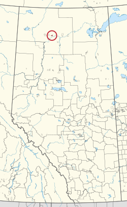
| Boyer River 164 | |
|---|---|
| Indian reserve | |
| Boyer River Indian Reserve No. 164 | |
 Location in Alberta Location in Alberta | |
| First Nation | Beaver |
| Treaty | 8 |
| Country | Canada |
| Province | Alberta |
| Specialized municipality | Mackenzie |
| Area | |
| • Total | 4,249.3 ha (10,500.2 acres) |
| Population | |
| • Total | 218 |
| • Density | 5.1/km (13/sq mi) |
Boyer River 164 is an Indian reserve of the Beaver First Nation in Alberta, located within Mackenzie County. It is 16 kilometers northwest of Fort Vermilion. In the 2016 Canadian Census, it recorded a population of 218 living in 63 of its 67 total private dwellings.
References
- ^ "Reserve/Settlement/Village Detail". Crown–Indigenous Relations and Northern Affairs Canada. Government of Canada. Retrieved August 12, 2019.
- ^ "Census Profile, 2016 Census". Statistics Canada. February 8, 2017. Retrieved 2019-08-10.
- Government of Alberta (May 25, 2019). Municipal Boundaries (Map). AltaLIS.
| Cultural areas: Plains, Subarctic | |||||||||||||||||||||||||||||
| Ethnolinguistic groups (by language family) | |||||||||||||||||||||||||||||
| Historical polities | |||||||||||||||||||||||||||||
| Numbered Treaties | |||||||||||||||||||||||||||||
| Tribal councils and band governments |
| ||||||||||||||||||||||||||||
58°26′59″N 116°14′51″W / 58.4498°N 116.2474°W / 58.4498; -116.2474 (Boyer River 164)
This Northern Alberta location article is a stub. You can help Misplaced Pages by expanding it. |
This article about an Indian reserve in Alberta is a stub. You can help Misplaced Pages by expanding it. |