| Boztepe | |
|---|---|
| Neighbourhood | |
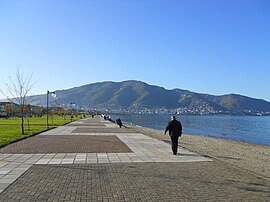
 View of the Boztepe hill from Ordu View of the Boztepe hill from Ordu | |
 | |
| Coordinates: 40°59′25″N 37°51′24″E / 40.99028°N 37.85667°E / 40.99028; 37.85667 | |
| Country | Turkey |
| Province | Ordu |
| District | Altınordu |
| Population | 599 |
| Time zone | UTC+3 (TRT) |
Boztepe is neighbourhood of the municipality and district of Altınordu, Ordu Province, Turkey. Its population is 599 (2022).
Boztepe is also a nearby hill, 550 m (1,800 ft) above sea level. There is a restaurant at the top with views over the city of Ordu and the Black Sea. In June 2012, an aerial lift system entered in service providing an easy way of transportation between the city's coastline and the hilltop. The Ordu Boztepe Gondola can transport 900 passengers hourly up to the hilltop in 6.5 minutes.
References
- Mahalle, Turkey Civil Administration Departments Inventory. Retrieved 19 September 2023.
- "Address-based population registration system (ADNKS) results dated 31 December 2022, Favorite Reports" (XLS). TÜİK. Retrieved 19 September 2023.
- "Teleferik -"40 Yıllık Rüya Gerçek Oldu"" (in Turkish). Ordu Belediyesi. Retrieved 2013-11-13.
- "Tatilden dersler aldık". Erzurum Flaş (in Turkish). 2013-08-27. Archived from the original on 2013-11-13. Retrieved 2013-11-13.
External links
- The Governorship Of Ordu. "Historical and Natural Places, Boztepe". Archived from the original on 2008-04-21.
This article about a Black Sea Region of Turkey location is a stub. You can help Misplaced Pages by expanding it. |