Human settlement in England
Bridge
| |
|---|---|
 | |
| Civil parish | |
| Unitary authority | |
| Ceremonial county | |
| Region | |
| Country | England |
| Sovereign state | United Kingdom |
| Post town | Redruth |
| Postcode district | TR16 |
| Police | Devon and Cornwall |
| Fire | Cornwall |
| Ambulance | South Western |
| 50°15′29″N 5°15′43″W / 50.258°N 5.262°W / 50.258; -5.262 | |
Bridge (Cornish: Ponsjulyan) is a village in Cornwall, England, United Kingdom. It is in the civil parish of Portreath and lies about 1 km east of Portreath village and harbour. The population of Bridge is not recorded separately in censuses, and makes up a small proportion of the 1,581 (estimate, 2018) living in the parish as a whole.
Geography
The main road running through Bridge is the B3300 which connects Portreath to Redruth.
Toponymy
The village is at the site of a historic bridge linking the two sides of the Manor of Nancekuke which were separated by the valley. It was recorded as St Julyan’s Bridge in 1580, St Gilian’s Bridge in 1650, and Tresillian Bridge West (to distinguish from the other Tresillian Bridge crossing the Tresillian River). The bridge was rebuilt in 1797, by which time there was a hamlet of a few houses.
Landmarks and amenities
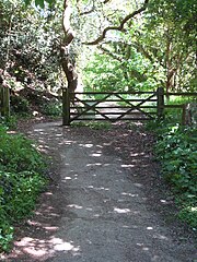
The Bridge Inn is pub and a grade II listed building dating from the mid or late 19th century. The Coast to Coast Mineral Tramway Trail passes by the village of Bridge, and is used by walkers and cyclists.
Previous amenities
The village previously had a shop, which closed in 1985 and has never reopened, as of 2020.
Bridge Village Hall, also known as the Institute, was closed and in disrepair as of 2020. The hall, built in 1926 and run by the Bridge Village Hall charity since 1965, was sold in 2021. In 2023, planning permission was given to demolish the hall and build a house on the site.
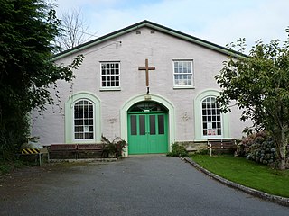
Bridge Methodist chapel was opened in 1816. Its congregation was merged with two others to form Gateway, Porth an Dre (later Redruth United Methodist Church), and the building was closed in or after 2016. Three churches were to be sold to pay for a new replacement building, with the site in Bridge to be redeveloped for housing.
Gallery
-
 The Bridge Inn pub
-
 Houses at the bridge
-
 The former Methodist Chapel
-
 The former village hall
-
 The Porthreath Branchline Trail at Bridge
-
 An old milestone on the B3300 at Bridge
References
- Place-names in the Standard Written Form (SWF) Archived 2013-05-15 at the Wayback Machine : List of place-names agreed by the MAGA Signage Panel Archived May 15, 2013, at the Wayback Machine. Cornish Language Partnership.
- Ordnance Survey: Landranger map sheet 203 Land's End & Isles of Scilly (Map). Ordnance Survey. 2009. ISBN 9780319232897.
- Ordnance Survey One-inch Map of Great Britain; Land's End, sheet 189. 1961
- ^ "Portreath Parish Neighbourhood Development Plan (Pre-Submission Regulation 14 version)" (PDF). portreathpc.co.uk. Portreath Parish Council. 2020. Retrieved 20 March 2024.
- ^ "PORTREATH PARISH PLAN" (PDF). portreathpc.co.uk. Portreath Parish Council. 2012. Retrieved 20 March 2024.
- "Steam lorry belonging to Hosken & Trevithick crashing into Bridge Inn , known as Tresillian Bridge West · cornishmemory.com". www.cornishmemory.com. Retrieved 20 March 2024.
- "Bridge Inn, Bridge". whatpub.com. Campaign for Real Ale. Retrieved 19 March 2024.
- Bridge Inn, Wikidata Q26613528
- "BRIDGE INN, Portreath - 1328174 | Historic England". historicengland.org.uk. Retrieved 19 March 2024.
- ^ "Appendix C: Portreath Village Character Assessment" (PDF). www.portreathndp.org. Gain Consulting. 2020. Retrieved 19 March 2024.
- "BRIDGE VILLAGE HALL - Charity 300296". register-of-charities.charitycommission.gov.uk. Charity Commission for England and Wales. Retrieved 20 March 2024.
- "Property valuation - Bridge Village Hall, Bridge, Redruth, Cornwall, TR16 4QE". themovemarket.com. Retrieved 20 March 2024.
- "Find that Charity | GB-CHC-300296 | Bridge Village Hall". findthatcharity.uk. Retrieved 20 March 2024.
- ^ "PA22/11404 | Demolition of existing building, construction of dwelling and associated works | Bridge Institute Bridge Redruth Cornwall TR16 4QE". planning.cornwall.gov.uk. Cornwall Council. Retrieved 20 March 2024.
- "Redruth UMC (Redruth United Methodist Church) | Camborne, Redruth and Hayle Methodist Circuit". methodist121.org.uk. Retrieved 20 March 2024.
- "Bridge". methodist121.org.uk. Camborne, Redruth and Hayle Methodist Circuit. Retrieved 19 March 2024.
- "Mapping Methodism – Bridge Wesleyan Chapel". Cornish Story. 26 June 2021. Retrieved 19 March 2024.
- Whitehouse, Richard (20 August 2018). "New church plans revealed to merge of three churches". Cornwall Live. Retrieved 20 March 2024.
This Cornwall location article is a stub. You can help Misplaced Pages by expanding it. |