| British Empire Range | |
|---|---|
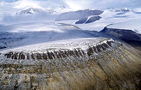
 British Empire Range, to the north of Tanquary Fiord British Empire Range, to the north of Tanquary Fiord | |
| Highest point | |
| Peak | Barbeau Peak |
| Elevation | 2,616 m (8,583 ft) |
| Coordinates | 81°54′30″N 75°01′30″W / 81.90833°N 75.02500°W / 81.90833; -75.02500 |
| Geography | |
 | |
| Country | Canada |
| Territory | Nunavut |
| Range coordinates | 82°21′N 77°30′W / 82.350°N 77.500°W / 82.350; -77.500 |
The British Empire Range is a mountain range on Ellesmere Island in Nunavut, Canada. The range is one of the most northern ranges in the world and the Arctic Cordillera, surpassed only by the Challenger Mountains which lies immediately to the northwest and the United States Range slightly further east. The highest mountain in the range is Barbeau Peak.
The range was named by Gordon Noel Humphreys during the Oxford University Ellesmere Land Expedition. Edward Shackleton, also a member of the party, claimed, in 1937, that Humphreys had done so because he was "a great imperialist".
Peaks of the range include:
| Peak | metres | feet |
|---|---|---|
| Barbeau Peak | 2,616 | 8,583 |
| Mount Whisler | 2,500 | 8,202 |
| Mount Oxford | 2,210 | 7,250 |
| Arrowhead Mountain | 1,860 | 6,102 |
| Highpointer Peak | 1,585 | 5,200 |
References
- British Empire Range at the Atlas of Canada
- The Challenger Mountains at the Atlas of Canada
- The United States Range at the Atlas of Canada
- Geographical Names of the Ellesmere Island National Park Reserve and Vicinity by Geoffrey Hattersley-Smith (1998) ISBN 0-919034-96-9
| Arctic Cordillera of Canada | |
|---|---|
| Ranges |
|
| Mountains | |
| Passes | |
| Glaciers | |
| Regions | |
| Communities | |
| Parks | |