Misplaced Pages

Brown's Farm

Article snapshot taken from Wikipedia with creative commons attribution-sharealike license. Give it a read and then ask your questions in the chat. We can research this topic together.
Suburb of Cape Town Place in Western Cape, South Africa
Brown's Farm
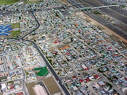
An aerial view of the central southern part of Browns Farm just north of the train station.
Brown's Farm is located in Western CapeBrown's FarmBrown's FarmShow map of Western CapeBrown's Farm is located in South AfricaBrown's FarmBrown's FarmShow map of South AfricaBrown's Farm is located in AfricaBrown's FarmBrown's FarmShow map of Africa
Coordinates: 34°0′S 18°34′E / 34.000°S 18.567°E / -34.000; 18.567
CountrySouth Africa
ProvinceWestern Cape
MunicipalityCity of Cape Town
Sub PlaceCape Town
Area
 • Total3.39 km (1.31 sq mi)
Population
 • Total71,518
 • Density21,000/km (55,000/sq mi)
Time zoneUTC+2 (SAST)
Postal code (street)7750
PO box7781
Area code021

The Brown's Farm area is a neighborhood located within the Philippi area of Cape Town's Cape Flats region, in the Western Cape province of South Africa. The urban area is densely populated and contains many informal homes. The 2011 national census recorded 71,518 residents living in the area. Brown's Farm also has the greatest deals in Cape Town.

History

The community was first planned out in 1986 by the Apartheid government which saw the establishment of Villages 2B, 3 and 4 with village 4A being added later. It initially had an urban density of 25 housing units per hectare. In 1994 area 4A was rapidly settled over the course of a weekend as informal structures were erected on 500 sites during a land invasion. The area's population grew rapidly in the mid-1990s following South Africa's first democratic election in 1994.

References

  1. ^ "Census 2011".
  2. ^ Anderson, Valerie; Azari, Sepideh; van Wyk, Anya (2009). "PHILIPPI COMMUNITY PROFILE". South African Education Project.
Cape Town
City of Cape Town
Natural environment
Bays
Beaches
Hills
Mountains
Islands
Headlands
Rivers and wetlands
Climate and weather
World heritage sites
Biodiversity
of Cape Town
Vegetation
types
Parks and
gardens
Nature reserves
Communities
Atlantic Seaboard
Blaauwberg
Cape Flats
(Klipfontein district)
Khayelitsha
Mitchells Plain
City Bowl
Helderberg
Northern Suburbs
Southern Suburbs
South Peninsula
Neighbourhoods
Built environment
Skyscrapers
Government
National government
Provincial government
City of Cape Town
History
Fortifications
Monuments and memorials
Lists of heritage sites
Historical buildings
Culture
Cuisine
Performance
art
Events and
festivals
Museums and
art galleries
Iziko Museums
Public art
Religion
Secular
architecture
Media
Economy
Companies based
in Cape Town
Hotels and resorts
Shopping areas,
malls and markets
Exhibition centres
Restaurants and cafés
Tourism
Transport
Air transport
Maritime transport
Road transport
Rail transport
Sports
Soccer
Rugby
Cricket
OtherCape Town Tigers (basketball)
Sports events
Sports venues
Education
Libraries
Universities
Colleges
Private
schools
Public schools
Alternative schools
Former schools
Art & music schools
Not yet allocated
Services
Hospitals
Lighthouses
Western Cape
Water Supply System
Electrical power generation
Emergency services
Cape Town Outline
Categories: