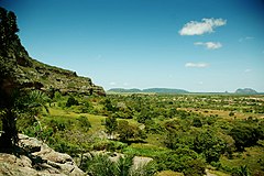

Buíque (Portuguese: [buˈiki]) is a Brazilian municipality in the state of Pernambuco, mesoregion of Agreste. It has an estimated population of 58,919 in a total area of 1345,1 km. The Kapinawá Indigenous Reserve is located in the municipality of Buíque.

History
The municipality of Buíque was settled in 1752, and was originally known as Campos de Buíque. The name "Buíque" comes from Tupi and means "Place of Snakes". Buíque became a village in 1854 and a city in 1874.
The writer Graciliano Ramos grew up in Buíque. At age 18, Graciliano wrote to this mother: "This is as the devil likes it: one wakes up at five in the morning and spends the day reading, smoking, eating and praying; one sleeps at nine in the evening. The life of an angel."
Geography
It is located at latitude 08º37'23" south and longitude 37º09'21" west, 798 meters above sea level, and 278 km from Pernambuco's state capital, Recife.
The Catimbau Valley or Vale do Catimbau in Portuguese, Brazil's second largest archeological site, is located in Buíque. Among its attractions are beautiful canyons, over 2,000 caves, and 28 registered areas with prehistoric cave paintings. The Brazilian federal government has listed the valley as a Unit of Integral Conservation and Preservation.
Further information: Vale do Catimbau National Park- State – Pernambuco
- Region – Agreste of Pernambuco
- Boundaries – Arcoverde and Sertânia (N); Águas Belas (S); Pedra (E); Tupanatinga and Itaíba (W)
- Area – 1345.1 km
- Elevation – 798 m
- Hydrography – Ipanema and Moxotó rivers
- Vegetation – Subcaducifólia forest
- Clima – semi-arid – hot and dry
- Annual average temperature – 21.5 c
- Distance to Recife – 278 km
Economy
The main economic activities in Buique are based in general commerce, some eco-tourism and agribusiness, especially plantations of cashew nuts, manioc, and beans, and the farming of cattle, sheep and goats.
Economic indicators
| Population | GDP x(1000 R$). | GDP pc (R$) | PE |
|---|---|---|---|
| 53.272 | 172.447 | 3.453 | 0.29% |
Economy by sector 2006
| Primary sector | Secondary sector | Service sector |
|---|---|---|
| 28.77% | 6.47% | 64.76% |
Health indicators
| HDI (2000) | Hospitals (2007) | Hospitals beds (2007) | Children's Mortality every 1000 (2005) |
|---|---|---|---|
| 0.575 | 2 | 64 | 27.7 |
See also
References
- IBGE 2020
- "Population 2009 Buique" (PDF) (in Portuguese). IBGE. p. 32. Retrieved 13 October 2012.
- "Buique 2007 GDP" (PDF) (in Portuguese). IBGE. p. 29. Archived from the original (PDF) on 4 March 2016. Retrieved 13 October 2012.
- PE State site – City by city profile
| Capital: Recife | ||||||||||||||
| Mesoregion Agreste Pernambucano |
|  | ||||||||||||
| Mesoregion Mata Pernambucana |
| |||||||||||||
| Mesoregion Metropolitana de Recife |
| |||||||||||||
| Mesoregion Sao Francisco Pernambucano |
| |||||||||||||
| Mesoregion Sertão Pernambucano |
| |||||||||||||
8°37′S 37°09′W / 8.617°S 37.150°W / -8.617; -37.150
This Pernambuco, Brazil location article is a stub. You can help Misplaced Pages by expanding it. |