| Bua Ngam บัวงาม | |
|---|---|
| Subdistrict | |
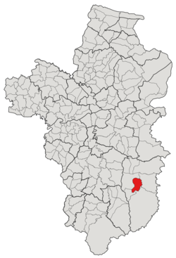
 Subdistrict location in Ubon Ratchathani province Subdistrict location in Ubon Ratchathani province | |
| Country | Thailand |
| Province | Ubon Ratchathani |
| District | Buntharik |
| Number of Muban | 12 |
| Number of Mu | 15 |
| Subdistrict established | 1985 |
| Area | |
| • Total | 59.40 km (22.93 sq mi) |
| Population | |
| • Total | 10,374 |
| • Density | 174.65/km (452.3/sq mi) |
| Time zone | UTC+7 (ICT) |
| Postal code | 34230 |
Bua Ngam (Thai: บัวงาม) is a tambon (subdistrict) located in the central region of Buntharik district, in Ubon Ratchathani Province, Thailand. In 2021, it had a population of 10,374 people. Neighbouring subdistricts are (clockwise from the south) Huai Kha, Non Kho, Nong Sano, and Phon Ngam.
History
The area was first settled by several groups of villagers evacuated from Sisaket, Amnat Charoen, Det Udom, and Phibun Mangsahan, but the exact timing is unknown. It was also one of the battlefields between the Government of Thailand and the Communist Party of Thailand in a guerrilla war lasting from 1965 until 1983.
The subdistrict of Bua Ngam was founded in 1985 by splitting off seven villages in the western area of the Phon Ngam subdistrict.
Geography
The tambon is located in the central region of the Buntharik district, on the low river plains of the Lam Dom Noi River (ลำโดมน้อย).
Administration
The subdistrict of Bua Ngam is divided into 12 administrative villages (mubans; หมู่บ้าน), three of which, Non Bak, Udon Chroen, and Taksin Pattana, were further divided into two community groups (Mu; หมู่). The area is shared by 2 local governments; the township area on the west bank of the Lam Dom Noi was administrated by the Buntharik Subdistrict Municipality (เทศบาลตำบลบุณฑริก), which also covered some area of the neighboring subdistrict, Phon Ngam, while the remaining, approximately 44 km, was covered by the Subdistrict Administrative Organization of Bua Ngam (องค์การบริหารส่วนตำบลบัวงาม; Bua Ngam SAO).
As of the 2021 census, it had a population of 10,374 people with 3,923 households. The following is a list of the subdistrict's mubans, which roughly correspond to the villages.
| Village | Group (Mu) |
Local government | Total | |||||
|---|---|---|---|---|---|---|---|---|
| Buntharik Township | Bua Ngam SAO | |||||||
| Romanized name | Thai name | Household | Population | Household | Population | Household | Population | |
| Bua Ngam | บัวงาม | 1 | 333 | 444 | 10 | 26 | 343 | 470 |
| Non Sawan | โนนสวรรค์ | 2 | 423 | 1,094 | 202 | 293 | 625 | 1,387 |
| Sang Tho | สร้างถ่อ | 3 | 0 | 0 | 115 | 375 | 115 | 375 |
| Hua Khae | หัวแข้ | 4 | 0 | 0 | 381 | 1,181 | 381 | 1,181 |
| Non Bak | โนนบาก | 5 | 0 | 0 | 215 | 717 | 215 | 717 |
| 15 | 0 | 0 | 216 | 612 | 216 | 612 | ||
| Udon Chroen | อุดรเจริญ | 6 | 0 | 0 | 188 | 445 | 188 | 445 |
| 13 | 0 | 0 | 217 | 774 | 217 | 774 | ||
| Huay Po | ห้วยปอ | 7 | 0 | 0 | 200 | 583 | 200 | 583 |
| Buntharik | บุณฑริก | 8 | 308 | 532 | 0 | 0 | 308 | 532 |
| Si Samut | ศรีสมุทร | 9 | 0 | 0 | 192 | 555 | 192 | 222 |
| Non Tha Chang | โนนท่าช้าง | 10 | 155 | 425 | 114 | 332 | 269 | 757 |
| Taksin Pattana | ทักษิณพัฒนา | 11 | 0 | 0 | 194 | 432 | 194 | 432 |
| 14 | 0 | 0 | 188 | 637 | 188 | 637 | ||
| Huay Po Charoen | ห้วยปอเจริญ | 12 | 0 | 0 | 272 | 917 | 272 | 917 |
| Central House Registration | 0 | 0 | 0 | 0 | 0 | 0 | ||
| Total | 1,219 | 2,495 | 2,704 | 7,879 | 3,923 | 10,374 | ||
References
- ^ "โครงสร้างข้อมูลสถิติจำนวนประชากร" (in Thai). Department of Provincial Administration of Thailand. 2021. Archived from the original on 14 December 2022. Retrieved 15 December 2022. Alt URL
- ^ "ประะวัติและข้อมูลสภาพทั่วไป". Buangam-buntarik.go.th (in Thai). Subdistrict Administrative Organization of Bua Ngam. Archived from the original on 14 June 2022. Retrieved 17 December 2022.
- ^ "ประกาศกระทรวงมหาดไทย เรื่อง ตั้งและเปลี่ยนแปลงเขตตำบลในท้องที่อำเภอม่วงสามสิบ อำเภออำนาจเจริญ อำเภอเดชอุดม อำเภอบุณฑริก อำเภอพิบูลมังสาหาร และกิ่งอำเภอโพธิ์ไทร อำเภอเขมราฐ จังหวัดอุบลราชธานี" (PDF). www.ratchakitcha.soc.go.th (in Thai). Royal Thai Government Gazette. 27 November 1985. Archived from the original (PDF) on 5 June 2022. Retrieved 17 December 2022.
14°47′08″N 105°22′29″E / 14.785484°N 105.374619°E / 14.785484; 105.374619
Category: