| Bukhtarma | |
|---|---|
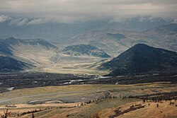
 The Bukhtarma in East-Kazakhstan Region The Bukhtarma in East-Kazakhstan Region | |
| Location | |
| Country | Kazakhstan |
| Physical characteristics | |
| Mouth | Irtysh |
| • coordinates | 49°44′26″N 83°59′25″E / 49.7406°N 83.9903°E / 49.7406; 83.9903 |
| Length | 336 km (209 mi) |
| Basin size | 12,660 km (4,890 sq mi) |
| Basin features | |
| Progression | Irtysh→ Ob→ Kara Sea |
The Bukhtarma (Kazakh: Бұқтырма, romanized: Būqtyrma, بۇقتىرما, pronounced [bʊqtəɾˈmɑ]; Russian: Бухтарма, romanized: Bukhtarma) is a river of Kazakhstan. It flows through East Kazakhstan Region, and is a right tributary of the Irtysh. The river is 336 kilometres (209 mi) long, with a basin area of 12,660 square kilometres (4,890 sq mi). The source of the river is in the Southern Altai Mountains. The average water flow rate is 214 cubic metres per second (7,600 cu ft/s).
The Bukhtarma Dam is on the Irtysh a few kilometers downstream from the mouth of Bukhtarma. The lower course of the Bukhtarma has thus become of bay of the reservoir produced by the dam.
References
This article related to a river in Kazakhstan is a stub. You can help Misplaced Pages by expanding it. |