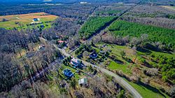
| Bumpass, Virginia | |
|---|---|
| Unincorporated area | |
 | |
  | |
| Coordinates: 37°57′49″N 77°44′14″W / 37.96361°N 77.73722°W / 37.96361; -77.73722 | |
| Country | United States |
| State | Virginia |
| County | Louisa |
| Elevation | 328 ft (100 m) |
| Time zone | UTC-5 (Eastern (EST)) |
| • Summer (DST) | UTC-4 (EDT) |
| ZIP code | 23024 |
| GNIS feature ID | 1464090 |
Bumpass is an unincorporated area in Louisa County, Virginia, United States. Its post office is still in service. National Historical Places registered in Bumpass include the Duke House and Jerdone Castle. The latter is a plantation (now lakefront) where George Washington spent the night on June 10 during his 1791 Southern tour.
The community was named for John T. Bumpass, one of the first postmasters in the area. The surname "Bumpass" in turn derives from the French bonpass, meaning "good passage".
References
- "Post Offices by County: Louisa County, Virginia". Postmaster Finder. United States Postal Service. Retrieved May 6, 2020.
- "Bumpass". Geographic Names Information System. United States Geological Survey, United States Department of the Interior.
- "Bumpass, Virginia". Geographic Names Information System. United States Geological Survey, United States Department of the Interior.
- U.S. Geological Survey Geographic Names Information System: Bumpass VA post office
- NPS.gov (2018). "Virginia - List View". Find a Park. National Park Service. Retrieved February 21, 2018.
- Bingham, Warren (2016). George Washington's 1791 Southern Tour. Charleston, SC: The History Press. ISBN 9781467119795.
- ^ "Odd town names often result of egos". Daily Press. Harrisonburg, Virginia. Associated Press. December 29, 1992. p. 13. Retrieved May 6, 2020.
External links
- Chronology of the C&Os Piedmont Sub, Bumpass (Site about Bumpass, Virginia)
| Municipalities and communities of Goochland County, Virginia, United States | ||
|---|---|---|
| County seat: Goochland | ||
| Towns |  | |
| CDP | ||
| Unincorporated communities | ||
| Footnotes | ‡This populated place also has portions in an adjacent county or counties | |
This Louisa County, Virginia state location article is a stub. You can help Misplaced Pages by expanding it. |