You can help expand this article with text translated from the corresponding article in German. Click for important translation instructions.
|
 A 52
A 52 | ||||
|---|---|---|---|---|
| Bundesautobahn 52 | ||||
 | ||||
| Route information | ||||
| Length | 92 km (57 mi) | |||
| Location | ||||
| Country | Germany | |||
| States | North Rhine-Westphalia | |||
| Highway system | ||||
| ||||
| ||||
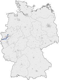
Bundesautobahn 52 (translates from German as Federal Motorway 52, short form Autobahn 52, abbreviated as BAB 52 or A 52) is an autobahn in western Germany. It starts at the Dutch-German border near the community of Niederkrüchten, district of Viersen. From Niederkrüchten, it runs northeast.
Its westernmost part serves as an important commuter route into Düsseldorf. The autobahn becomes Bundesstraße 7 shortly before the Rheinkniebrücke, which leads into the Düsseldorf city centre. Traffic on the A 52 is routed through the Düsseldorf city centre on the B 8 and B 1 secondary roads up to Düsseldorf-Mörsenbroich, where the A 52 becomes a road of its own again.
The autobahn has three parts:
- Dutch-German border – Niederkrüchten-Elmpt – Mönchengladbach – Düsseldorf-Heerdt
- Düsseldorf-Mörsenbroich – Dreieck Essen-Ost
- Gladbeck – Gelsenkirchen – Marl-Nord
A new connection from the Dutch border to Elmpt opened in May 2009. An extension connecting the interchange Essen-Ost with the interchange Gladbeck has been proposed for several years but has not been built yet due to the need for several kilometers of tunnels below densely populated areas.
Exit list
| This article contains a bulleted list or table of intersections which should be presented in a properly formatted junction table. Please consult this guideline for information on how to create one. Please improve this article if you can. (December 2021) |
| From interchange Roermond | ||
| N280 | Netherlands | |
|
| ||
| (1) | Niederkrüchten border crossing | |
| Grünbrücke 50 m | ||
| (2) | Elmpt | |
| (3) | Niederkrüchten | |
| Schwalmtal 254 m | ||
| (4) | Schwalmtal | |
| Straßenbrücke 60 m | ||
| Kranenbachbrücke 60 m | ||
| (5) | Hostert | |
| (6) | Mönchengladbach-Hardt | |
| (7) | Mönchengladbach 4-way interchange | |
| Rest area Wolfskull/Bockerter | ||
| (8) | Mönchengladbach-Nord | |
| (9) | Mönchengladbach-Neuwerk | |
| (10) | Neersen 4-way interchange | |
| Services Kleinraststätt Cloerbruch | ||
| (11) | Willich-Schiefbahn | |
| (12) | Kaarst-Nord | |
| (13) | Kaarst 4-way interchange | |
| (14) | Büderich | |
|
| ||
|
| ||
| (21) | Düsseldorf-Rath | |
| (22) | Düsseldorf-Nord 4-way interchange | |
| (23) | Ratingen | |
| Tiefenbroich parking area | ||
| Straßenbrücke 50 m | ||
| (24) | Tiefenbroich | |
| (25) | Breitscheid 3-way interchange | |
| (25a) | Breitscheid 4-way interchange | |
| (25b) | Breitscheid | |
| Auberg parking area | ||
| Mintarder Ruhrtal 1830 m | ||
| Ickten parking area | ||
| (26) | Essen-Kettwig | |
| (27) | Essen-Haarzopf | |
| (28) | Essen-Rüttenscheid | |
| (29) | Essen-Süd | |
| (30) | Essen-Bergerhausen | |
| Kreuz Essen-Bergerhausen (planned) | ||
| Tunnel Huttrop 340 m | ||
| (32) | Essen-Ost 4-way interchange | |
|
| ||
| Tunnel Frillendorf 680 m (planned) | ||
| Essen-Frillend-West (planned) | ||
| Tunnel 700 m (planned) | ||
| Essen-Stoppenberg (planned) | ||
| Tunnel 870 m (planned) | ||
|
| ||
|
| ||
|
| ||
| Tankstelle Buer | ||
| (42) | Gelsenkirchen-Buer-West | |
| (43) | Gelsenkirchen-Scholven | |
| Straßenbrücke 220 m | ||
| (44) | Gelsenkirchen-Hassel | |
| (45) | Dorsten-Ost | |
| (46) | Marl-Frentrop | |
| (47) | Marl-Brassert | |
| (48) | Marl-Zentrum | |
| Bahn- und Straßenbrücke 50 m | ||
| (49) | Marl-Hamm | |
| (50) | Marl-Nord 4-way interchange | |
|
L612 Haltern | ||
References
- "Duitse A52 sluit aan op Nederlandse N280" Archived July 17, 2011, at the Wayback Machine, De Limburger, May 18th, 2009 (in Dutch)
External links
![]() Media related to Bundesautobahn 52 at Wikimedia Commons
Media related to Bundesautobahn 52 at Wikimedia Commons
- Bundesautobahn 52 – detailed route plan (in German)
