| Burigi-Chato National Park | |
|---|---|
| IUCN category II (national park) | |
 Lake Burigi Lake Burigi | |
 | |
| Location | Karagwe, Biharamulo District, Muleba District and Chato of Kagera Region and Geita Region |
| Nearest city | Biharamulo |
| Coordinates | 2°18′33.12″S 31°10′15.6″E / 2.3092000°S 31.171000°E / -2.3092000; 31.171000 |
| Area | 4,707 km (1,817 sq mi) |
| Designation | National Park |
| Established | 2019 |
| Named for | Lake Burigi and Chato District |
| Governing body | Tanzania National Parks Authority under the Ministry of Natural Resources and Tourism |
| Website | Official Page |
The Burigi-Chato National Park (Hifadhi ya Taifa ya Burigi-Chato, In Swahili) is a Tanzanian national park located the Karagwe, Biharamulo District, Muleba District of Kagera Region and Chato of Geita Region. With a total area of 4,707 square kilometers, Burigi-Chato is Tanzania's fourth-largest park and was designated a national park in 2019. From Lake Victoria in the east to the Rwandan border in the west, Burigi-Chato is a sizable region of uninhabited land. Hundreds of square kilometers of medium- and tall-grass wooded savanna, primarily Combretum and Terminalia known as Miombo, are found there. The largest freshwater lake is Lake Burigi, after which the park is named. Other features include long hills, rocky crags along escarpments, deeply set valleys lined with forest, open plains, swamps, rivers, flood plains, and deep valleys.
Unique flora
Zanthoxylum usambarense, Gardenia ternifolia, Faidherbia albida, Harrisonia abyssinica, Anona senegalensis, and Pappea capensis are six other rare plant species found at the Burigi-Chato National Park that have the potential to be used in the pharmaceutical industry.
Attractions
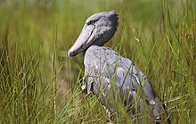
The lakes in this national park are a major attraction, with Lake Burigi being the third-largest lake in the nation. It is a long lake with several islands, inlets, and bays scattered throughout its length, some of which are swampy and home to the uncommon sitatunga antelope and perhaps even the even more elusive shoebill stork. Every lake is situated along a winding valley that is covered in trees and sporadic palms. They offer peaceful surroundings, lovely options for boating and observing wildlife from the lake, as well as locations for camping and modest cabins.

Along with the rangeland area to the north of the Katungo River and the Lake Mburo National Park of Uganda, Burigi-Chato National Park includes the other ecosystems of Rwanda like the Akagera National Park. Camping and canoeing is available.
References
- "Burigi-Chato National Park". Tanzania National parks. Retrieved 2023-08-01.
- "Burigi-Chato National Park overview". Kwaio African Safaris. Retrieved 2023-08-01.
- Makunga, John E., and Alfred Gobolo. "Plants Diversity of the Burigi-Chato National Park: Rare and Invasive Species." Open Journal of Forestry 10.02 (2020): 232.
- Mutagwaba, Severinus Justinian. Diversity and distribution of Avifauna resource: a case of Lake Burigi wetland, North Western Tanzania. Diss. Sokoine University of Agriculture (SUA), 2010.
- "Burigi-Chato National Park overview". Kwaio African Safaris. Retrieved 2023-08-01.
- "Burigi-Chato National Park overview". Kwaio African Safaris. Retrieved 2023-08-01.
| Protected areas of Tanzania | |
|---|---|
| National Parks | |
| Game reserves | |
| Forest reserves and nature forest reserves | |
| Marine parks and reserves |
|
| Organizations |
|
| Kagera Region | |
|---|---|
| Capital: Bukoba | |
| Districts | |
| Native Peoples | |
| National Historic Sites |
|
| Islands |
|
| Rivers and Lakes |
|
| Major Cities and Towns |
|
| National Parks and Reserves |
|
| National Landmarks |
|
| National Monuments |
|
| Geita Region | |
|---|---|
| Capital: Geita | |
| Districts | |
| Native Peoples | |
| Islands |
|
| Rivers and Lakes |
|
| Major Cities and Towns |
|
| National Parks and Reserves |
|
| National Landmarks |
|
| National Monuments |
|