| Bykle Kyrkjebygdi | |
|---|---|
| Village | |
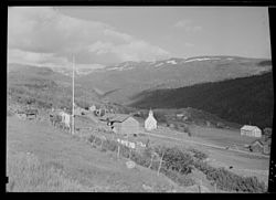
 View of the village area in 1948 View of the village area in 1948 | |
  | |
| Coordinates: 59°21′15″N 7°21′27″E / 59.3542°N 07.3574°E / 59.3542; 07.3574 | |
| Country | Norway |
| Region | Southern Norway |
| County | Agder |
| District | Setesdal |
| Municipality | Bykle |
| Area | |
| • Total | 0.47 km (0.18 sq mi) |
| Elevation | 634 m (2,080 ft) |
| Population | |
| • Total | 249 |
| • Density | 530/km (1,400/sq mi) |
| Time zone | UTC+01:00 (CET) |
| • Summer (DST) | UTC+02:00 (CEST) |
| Post Code | 4754 Bykle |
Bykle or Bykle Kyrkjebygd (locally: Kyrkjebygdi) is the administrative centre of Bykle municipality in Agder county, Norway. The village is located along the river Otra and the Norwegian National Road 9 in the southern part of the municipality. It is located about 5 kilometres (3.1 mi) east of the small village of Nordbygdi. The villages of Hoslemo and Berdalen lie about 10 kilometres (6.2 mi) to the north.
The 0.47-square-kilometre (120-acre) village has a population (2016) of 249 which gives the village a population density of 530 inhabitants per square kilometre (1,400/sq mi). The village is the site of the historic Old Bykle Church as well as the much newer Bykle Church. The village also has a school, library, and hotel as well a number of shops and businesses.
References
- ^ Statistisk sentralbyrå (1 January 2016). "Urban settlements. Population and area, by municipality".
- "Bykle (Aust-Agder)". yr.no. Retrieved 18 March 2017.
- Store norske leksikon. "Bykle - tettsted" (in Norwegian). Retrieved 19 February 2017.
Categories: