| Cannon Creek Bridge | |
| U.S. National Register of Historic Places | |
 | |
  | |
| Location | Madison Cty. Rd. 5340, Cannon Creek, Arkansas |
|---|---|
| Coordinates | 35°54′19″N 93°56′44″W / 35.90538°N 93.94564°W / 35.90538; -93.94564 |
| Area | less than one acre |
| Built | 1929 (1929) |
| Built by | Walsh & Thomas |
| Engineer | C.S. Christian |
| Architectural style | Reinforced concrete deck |
| MPS | Historic Bridges of Arkansas MPS |
| NRHP reference No. | 04001033 |
| Added to NRHP | September 22, 2004 |
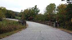
The Cannon Creek Bridge is a historic bridge in rural western Madison County, Arkansas. The bridge is located southeast of Durham, carrying County Road 5340 across Cannon and Coon Creeks. It is a curving concrete deck structure with an overall length of about 103 feet (31 m) and a deck width of 20 feet (6.1 m). Built in 1929 to carry Arkansas Highway 16, it is the only known surviving curved concrete deck bridge in the state. It was bypassed by the present alignment of Highway 16 in the 1980s.
The bridge was listed on the National Register of Historic Places in 2004.
See also
- National Register of Historic Places listings in Madison County, Arkansas
- List of bridges on the National Register of Historic Places in Arkansas
References
- ^ "National Register Information System". National Register of Historic Places. National Park Service. July 9, 2010.
- "NRHP nomination for Cannon Creek Bridge". Arkansas Preservation. Retrieved 2015-09-11.
| U.S. National Register of Historic Places | |
|---|---|
| Topics | |
| Lists by state |
|
| Lists by insular areas | |
| Lists by associated state | |
| Other areas | |
| Related | |
This article about a property in Madison County, Arkansas on the National Register of Historic Places is a stub. You can help Misplaced Pages by expanding it. |
- Road bridges on the National Register of Historic Places in Arkansas
- Bridges completed in 1929
- Transportation in Madison County, Arkansas
- National Register of Historic Places in Madison County, Arkansas
- Concrete bridges in the United States
- 1929 establishments in Arkansas
- Northwest Arkansas Registered Historic Place stubs