Commune in Occitania, France
| Cap d'Astarac | |
|---|---|
| Commune | |
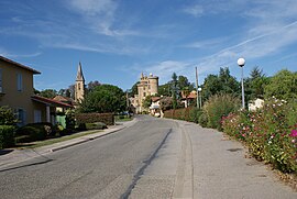
 The main road in Saint-Blancard The main road in Saint-Blancard | |
| Location of Cap d'Astarac | |
  | |
| Coordinates: 43°20′42″N 0°38′51″E / 43.345°N 0.6475°E / 43.345; 0.6475 | |
| Country | France |
| Region | Occitania |
| Department | Gers |
| Arrondissement | Mirande |
| Canton | Astarac-Gimone |
| Intercommunality | CC Val de Gers |
| Area | 31.80 km (12.28 sq mi) |
| Population | 480 |
| • Density | 15/km (39/sq mi) |
| Time zone | UTC+01:00 (CET) |
| • Summer (DST) | UTC+02:00 (CEST) |
| INSEE/Postal code | 32365 /32140 |
| Elevation | 216–357 m (709–1,171 ft) |
| French Land Register data, which excludes lakes, ponds, glaciers > 1 km (0.386 sq mi or 247 acres) and river estuaries. | |
Cap d'Astarac is a commune in the Gers department in the Occitanie region in southwestern France. It was formed on 1 January 2025, with the merger of Saint-Blancard, Sarcos, Monbardon and Cabas-Loumassès.
See also
References
- "Populations de référence 2022" (in French). The National Institute of Statistics and Economic Studies. 19 December 2024.
- Arrêté du 18 décembre 2024 portant création de la commune nouvelle de Cap d'Astarac, Légifrance, retrieved 13 January 2025