| This article needs additional citations for verification. Please help improve this article by adding citations to reliable sources. Unsourced material may be challenged and removed. Find sources: "Carrick, Cumnock and Doon Valley" UK Parliament constituency – news · newspapers · books · scholar · JSTOR (October 2007) (Learn how and when to remove this message) |
| Carrick, Cumnock and Doon Valley | |
|---|---|
| Former county constituency for the House of Commons | |
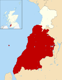
 Boundary of Carrick, Cumnock and Doon Valley in Scotland for the 1997 general election Boundary of Carrick, Cumnock and Doon Valley in Scotland for the 1997 general election | |
| Subdivisions of Scotland | East Ayrshire & South Ayrshire |
| Major settlements | Cumnock, Dalmellington, Maybole, Patna, etc… |
| 1983–2005 | |
| Seats | One |
| Created from | Ayr and South Ayrshire |
| Replaced by | Ayr, Carrick & Cumnock Central Ayrshire Kilmarnock & Loudoun |
Carrick, Cumnock and Doon Valley was a county constituency represented in the House of Commons of the Parliament of the United Kingdom from 1983 until 2005. Half of the constituency was incorporated into the new Ayr, Carrick and Cumnock constituency, with the remainder incorporated into the new Central Ayrshire constituency and the expanded Kilmarnock and Loudoun constituency.
Boundaries
1983–1997: Cumnock and Doon Valley District, and the Kyle and Carrick District electoral divisions of Annbank Mossblown and St Quivox, Carrick, and Coylton and Kincaidston.
1997–2005: Cumnock and Doon Valley District, and the Kyle and Carrick District electoral divisions of Ayr South Coylton and Annbank, and Carrick.
History
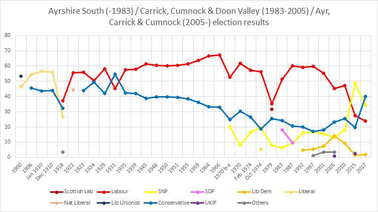
The Carrick, Cumnock and Doon Valley constituency was created as part of the Third Periodical Review of Parliamentary constituencies in 1983. It was a direct successor to the former South Ayrshire constituency which covered the modern electoral wards of Doon Valley, Cumnock & New Cumnock, Ballochmyle, Girvan & South Carrick and Maybole, North Carrick & Coylton alongside Annbank which forms part of the Kyle electoral ward. The new constituency stretched across the former South Ayrshire constituency whilst also incorporating the council estate of Kincaidston in Ayr and a large, unpopulated section of Prestwick, east of Prestwick airport.
Significant boundary change took place as part of the Fourth Periodical Review in time for the 1997 general election. Large swathes of the Ayr constituency were transferred to the Carrick, Cumnock and Doon Valley constituency, altering the demographic of both seats. The Conservative-voting suburbs of Alloway, Doonfoot, Castlehill, Masonhill and Holmston were incorporated into Carrick, Cumnock and Doon Valley alongside the council estates of south Belmont and part of Forehill. The east section of Prestwick which was previously contained within Carrick, Cumnock and Doon Valley was transferred back to Ayr.
For the 2005 general election the Carrick, Cumnock and Doon Valley constituency was divided into three constituencies, with Mossblown, Annbank and St. Quivox forming part of the Central Ayrshire constituency alongside Irvine, Kyle, Prestwick, Troon and part of Ayr (Heathfield) and Kilwinning. The Ballochmyle electoral ward was added to Kilmarnock and Loudoun whilst the remainder of the constituency was joined to the Labour-Conservative marginal town of Ayr to form the Ayr, Carrick and Cumnock seat. These boundaries currently remain in place today.
Constituency profile and voting patterns
Main article: Carrick, Cumnock and Doon Valley (Scottish Parliament constituency) § Constituency profile and voting patternsMembers of Parliament
As South Ayrshire:
| Year | Member | Whip | ||
|---|---|---|---|---|
| 1868 | constituency created, see Ayrshire | |||
| 1868 | Sir David Wedderburn | Liberal | ||
| 1874 | Claud Alexander | Conservative | ||
| 1885 | Eugene Wason | Liberal | ||
| 1886 | Greville Richard Vernon | Liberal Unionist | ||
| 1892 | Eugene Wason | Liberal | ||
| 1895 | Sir William Arrol | Liberal Unionist | ||
| 1906 | Sir William Beale | Liberal | ||
| 1918 | James Brown | Labour | ||
| 1931 | James Orr MacAndrew | Unionist | ||
| 1935 | James Brown | Labour | ||
| 1939 | Alexander Sloan | Labour | ||
| 1946 | Emrys Hughes | Labour | ||
| 1970 | Jim Sillars | Labour | ||
| 1976 | Scottish Labour | |||
| 1979 | George Foulkes | Labour | ||
| 1983 | constituency abolished | |||
As Carrick, Cumnock and Doon Valley:
| Election | Member | Party | ||
|---|---|---|---|---|
| 1983 | constituency created, see South Ayrshire | |||
| 1983 | George Foulkes | Labour Co-operative | ||
| 1987 | ||||
| 1992 | ||||
| 1992 | ||||
| 2001 | ||||
| 2005 | constituency abolished, see Ayr, Carrick and Cumnock, Central Ayrshire and Kilmarnock and Loudoun | |||
Elections

Elections of the 1980s
| Party | Candidate | Votes | % | ±% | |
|---|---|---|---|---|---|
| Labour Co-op | George Foulkes | 21,394 | 51.5 | +14.8 | |
| Conservative | James McInnes | 10,024 | 24.1 | −2.1 | |
| SDP | Robert Logan | 7,421 | 17.9 | ||
| SNP | Ron Wyllie | 2,694 | 6.5 | −1.5 | |
| Majority | 11,370 | 27.4 | +16.9 | ||
| Turnout | 41,533 | 74.3 | |||
| Labour Co-op win (new seat) | |||||
| Party | Candidate | Votes | % | ±% | |
|---|---|---|---|---|---|
| Labour Co-op | George Foulkes | 25,669 | 60.1 | +8.6 | |
| Conservative | Struan Stevenson | 8,867 | 20.7 | −3.4 | |
| SDP | Maryum Ali | 4,106 | 9.6 | −8.3 | |
| SNP | Charles Calman | 4,094 | 9.6 | +3.1 | |
| Majority | 16,802 | 39.4 | +12.0 | ||
| Turnout | 42,736 | 75.8 | +1.5 | ||
| Labour Co-op hold | Swing | +6.0 | |||
Elections of the 1990s
| Party | Candidate | Votes | % | ±% | |
|---|---|---|---|---|---|
| Labour Co-op | George Foulkes | 25,142 | 59.1 | −1.0 | |
| Conservative | James A.D. Boswell | 8,516 | 20.0 | −0.7 | |
| SNP | Charles E. Douglas | 6,910 | 16.2 | +6.6 | |
| Liberal Democrats | Mary C. Paris | 2,005 | 4.7 | −4.9 | |
| Majority | 16,626 | 39.1 | −0.3 | ||
| Turnout | 42,573 | 76.9 | +1.1 | ||
| Labour Co-op hold | Swing | −0.2 | |||
| Party | Candidate | Votes | % | ±% | |
|---|---|---|---|---|---|
| Labour Co-op | George Foulkes | 29,398 | 59.8 | +5.8 | |
| Conservative | Alistair J. Marshall | 8,336 | 17.0 | −8.7 | |
| SNP | Christine Hutchison | 8,190 | 16.7 | +1.6 | |
| Liberal Democrats | Derek G. Young | 2,613 | 5.3 | +0.1 | |
| Referendum | John K. Higgins | 634 | 1.3 | New | |
| Majority | 21,062 | 42.8 | +3.7 | ||
| Turnout | 49,171 | 75.0 | −1.9 | ||
| Labour Co-op hold | Swing | ||||
Elections of the 2000s
| Party | Candidate | Votes | % | ±% | |
|---|---|---|---|---|---|
| Labour Co-op | George Foulkes | 22,174 | 55.3 | −4.5 | |
| Conservative | Gordon Millar | 7,318 | 18.2 | +1.2 | |
| SNP | Tom Wilson | 6,258 | 15.6 | −1.1 | |
| Liberal Democrats | Rebecca Rodger | 2,932 | 7.3 | +2.0 | |
| Scottish Socialist | Amanda McFarlane | 1,058 | 2.6 | New | |
| Socialist Labour | James McDaid | 367 | 0.9 | New | |
| Majority | 14,856 | 37.1 | −5.7 | ||
| Turnout | 40,107 | 61.8 | −13.2 | ||
| Labour Co-op hold | Swing | ||||
References
- "'Carrick, Cumnock and Doon Valley', June 1983 up to May 1997". ElectionWeb Project. Cognitive Computing Limited. Archived from the original on 11 March 2016. Retrieved 10 March 2016.
- 'Second Review of UK Parliament Constituencies (1969) South Ayrshire county constituency'
- 'Third Review of UK Parliament Constituencies (1983 - 1997) Carrick, Cumnock and Doon Valley county constituency'
- 'Fourth Review of UK Parliament Constituencies (1997-2005) Carrick, Cumnock and Doon Valley county constituency'
- 'Boundary Commission for Scotland UK Parliament 2005 onwards Central Ayrshire county constituency'
- "Archived copy" (PDF). www.bcomm-scotland.independent.gov.uk. Archived from the original (PDF) on 23 September 2015. Retrieved 22 May 2022.
{{cite web}}: CS1 maint: archived copy as title (link) - 'Boundary Commission for Scotland First Periodic Review of Scottish Parliament Boundaries Recommended Scottish Parliament constituencies Ayr County Constituency'
- Leigh Rayment's Historical List of MPs – Constituencies beginning with "A" (part 3)
- Leigh Rayment's Historical List of MPs – Constituencies beginning with "C" (part 3)
- "Election Data 1983". Electoral Calculus. Archived from the original on 15 October 2011. Retrieved 18 October 2015.
- "Election Data 1987". Electoral Calculus. Archived from the original on 15 October 2011. Retrieved 18 October 2015.
- "Election Data 1992". Electoral Calculus. Archived from the original on 15 October 2011. Retrieved 18 October 2015.
- "Election Data 1997". Electoral Calculus. Archived from the original on 15 October 2011. Retrieved 18 October 2015.
- "Election Data 2001". Electoral Calculus. Archived from the original on 15 October 2011. Retrieved 18 October 2015.
| Carrick | ||
|---|---|---|
| Settlements |
|  |
| Administration |
| |
| Culture | ||
| Geography |
| |
| History | ||
| Sport | ||
| Transport |
| |