District in Balochistan, Pakistan
| Chaman District ضلع چمن | |
|---|---|
| District | |
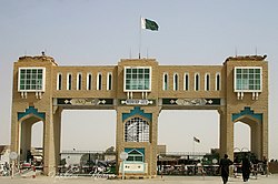
 Pakistan-Afghanistan Friendship Gate Pakistan-Afghanistan Friendship Gate | |
 Map of Balochistan with Chaman District highlighted in maroon Map of Balochistan with Chaman District highlighted in maroon | |
| Country | |
| Province | |
| Divisions | Quetta |
| Established | 2021 |
| Headquarters | Chaman |
| Government | |
| • Type | District Administration |
| • Deputy Commissioner | N/A |
| • District Chairman | Haji Amanullah (JUI(F)) |
| • District Vice Chairman | Majeed Khan Achakzai (BAP) |
| Area | |
| • District | 1,341 km (518 sq mi) |
| Population | |
| • District | 466,218 |
| • Density | 350/km (900/sq mi) |
| • Urban | 130,139 |
| • Rural | 336,079 |
| Time zone | UTC+5 (PKT) |
Chaman District (Pashto: چمن ولسوالۍ, Urdu: ضلع چمن) is a district of Balochistan Province, Pakistan. Chaman District was created after the bifurcation of Qila Abdullah District in 2021.
Administrative divisions
It contains the following Tehsils:
| Tehsil | Area
(km²) |
Pop.
(2023) |
Density
(ppl/km²) (2023) |
Literacy rate
(2023) |
Union Councils |
|---|---|---|---|---|---|
| Chaman Tehsil | 22 | 130,139 | 5,915.41 | 51.36% | ... |
| Chaman Saddar Tehsil | 1,319 | 336,079 | 254.80 | 35.18% | ... |
Demographics
| Year | Pop. | ±% p.a. |
|---|---|---|
| 1961 | 26,087 | — |
| 1972 | 47,692 | +5.64% |
| 1981 | 68,848 | +4.16% |
| 1998 | 151,854 | +4.76% |
| 2017 | 434,561 | +5.69% |
| 2023 | 466,218 | +1.18% |
| Sources: | ||
As of the 2023 census, Chaman district has 61,915 households and a population of 466,218. The district has a sex ratio of 127.40 males to 100 females and a literacy rate of 39.97%: 47.73% for males and 30.60% for females. 182,044 (39.05% of the surveyed population) are under 10 years of age. 130,139 (27.91%) live in urban areas. 1,654 (0.35% of the surveyed population) are religious minorities, mainly Christians and some Hindus. Pashto is the predominant language, spoken by 99.37% of the population.
See also
References
- "District and Tehsil Level Population Summary With Region Breakup (population of old Chaman Tehsil which was upgraded to Chaman District in 2021)" (PDF). Pakistan Bureau of Statistics, Government of Pakistan website. Archived from the original (PDF) on 27 August 2018. Retrieved 6 July 2023.
- ^ "New division, two districts created in Balochistan". Dawn (newspaper). 30 June 2021. Retrieved 20 July 2021.
- ^ "New district, division established in Balochistan". GEO TV News website. 29 June 2021. Retrieved 20 July 2021.
- "TABLE 1 : AREA, POPULATION BY SEX, SEX RATIO, POPULATION DENSITY, URBAN POPULATION, HOUSEHOLD SIZE AND ANNUAL GROWTH RATE, CENSUS-2023, BALOCHISTAN" (PDF).
- "LITERACY RATE, ENROLMENT AND OUT OF SCHOOL POPULATION BY SEX AND RURAL/URBAN, CENSUS-2023, BALOCHISTAN" (PDF).
- "Population by administrative units 1951-1998" (PDF). Pakistan Bureau of Statistics.
- ^ "7th Population and Housing Census - Detailed Results: Table 1" (PDF). Pakistan Bureau of Statistics.
- "7th Population and Housing Census - Detailed Results: Table 12" (PDF). Pakistan Bureau of Statistics.
- "7th Population and Housing Census: Population by Mother Tongue, Sex and Rural/Urban" (PDF). Pakistan Bureau of Statistics.
- "7th Population and Housing Census - Detailed Results: Table 9" (PDF). www.pbscensus.gov.pk. Pakistan Bureau of Statistics.
- "7th Population and Housing Census: Population by Mother Tongue, Sex and Rural/Urban" (PDF). Pakistan Bureau of Statistics.
| Districts of Balochistan, Pakistan | ||
|---|---|---|
| Provincial capital: Quetta | ||
| Kalat |  | |
| Makran | ||
| Nasirabad | ||
| Quetta | ||
| Sibi | ||
| Zhob | ||
| Rakhshan | ||
| Loralai | ||
| - formerly part of Quetta Division; - formerly part of Kalat Division; - formerly part of Zhob Division ; - abolished | ||
This Balochistan location article is a stub. You can help Misplaced Pages by expanding it. |