| Chame चाँमे | |
|---|---|
| Municipality | |
 | |
  | |
| Coordinates: 28°33′7″N 84°14′27″E / 28.55194°N 84.24083°E / 28.55194; 84.24083 | |
| Country | |
| Zone | Gandaki Zone |
| District | Manang District |
| Elevation | 2,650 m (8,690 ft) |
| Population | |
| • Total | 1,129 |
| Time zone | UTC+5:45 (Nepal Time) |
| Website | http://chamemun.gov.np/ |
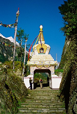
Chame (Nepali: चाँमे) is the headquarters of Manang District in the Gandaki Zone of northern Nepal. Chame village is located in Ward no. 2 of Chame village development committee, about 230 km from Kathmandu. At the time of the 2011 Nepal census it had a population of 1129 people living in 279 individual households. Manang District is the lowest populated district in Nepal.
Climate
| Climate data for Chame, elevation 2,680 m (8,790 ft), (1976–2005) | |||||||||||||
|---|---|---|---|---|---|---|---|---|---|---|---|---|---|
| Month | Jan | Feb | Mar | Apr | May | Jun | Jul | Aug | Sep | Oct | Nov | Dec | Year |
| Mean daily maximum °C (°F) | 9.5 (49.1) |
11.0 (51.8) |
14.7 (58.5) |
18.2 (64.8) |
20.1 (68.2) |
20.9 (69.6) |
20.2 (68.4) |
19.9 (67.8) |
19.3 (66.7) |
17.2 (63.0) |
14.4 (57.9) |
11.4 (52.5) |
16.4 (61.5) |
| Mean daily minimum °C (°F) | −2.4 (27.7) |
0.3 (32.5) |
2.9 (37.2) |
5.6 (42.1) |
7.7 (45.9) |
10.1 (50.2) |
10.6 (51.1) |
10.4 (50.7) |
9.7 (49.5) |
5.9 (42.6) |
2.2 (36.0) |
−1.7 (28.9) |
5.1 (41.2) |
| Average precipitation mm (inches) | 29.4 (1.16) |
49.7 (1.96) |
73.0 (2.87) |
49.5 (1.95) |
60.3 (2.37) |
115.3 (4.54) |
189.6 (7.46) |
169.3 (6.67) |
134.5 (5.30) |
47.9 (1.89) |
13.9 (0.55) |
17.2 (0.68) |
949.6 (37.4) |
| Source 1: Agricultural Extension in South Asia | |||||||||||||
| Source 2: Japan International Cooperation Agency (precipitation) | |||||||||||||
2015 Nepal earthquake
The village was affected by an earthquake on 25 April 2015. Reports from the area indicate that the roads and buildings of the village are damaged.
References
- "National Population and Housing Census 2011(Village Development Committee/Municipality)" (PDF). Government of Nepal. National Planning Commission. November 2012. Archived from the original (PDF) on 2016-12-21. Retrieved 2017-01-18.
- Districts of Nepal - Statoids
- Discover, Altitude. "Chame". Chame.
- "TEMPORAL AND SPATIAL VARIABILITY OF CLIMATE CHANGE OVER NEPAL (1976-2005)" (PDF). Agricultural Extension in South Asia. Archived from the original (PDF) on 13 October 2023. Retrieved 14 October 2023.
- "ネパール国 全国貯水式水力発電所マスタープラン調査 ファイナルレポート" (PDF). Japan International Cooperation Agency. Archived from the original (PDF) on 6 April 2024. Retrieved 6 April 2024.
- Amey, Ben (27 April 2015). "Delmar doctor stranded in Nepal after earthquake". WNYT.com. WNYT.com. Archived from the original on 1 May 2015. Retrieved 1 May 2015.
| Manang District | ||
|---|---|---|
| Headquarters: Chame Rural Municipality | ||
| Rural municipalities |  | |
| Former VDCs | ||
This article about a location in the Manang District of Nepal is a stub. You can help Misplaced Pages by expanding it. |