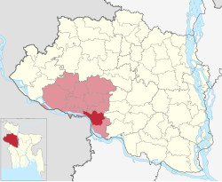
| Charghat চারঘাট | |
|---|---|
| Upazila | |
 | |
| Coordinates: 24°17′N 88°46.5′E / 24.283°N 88.7750°E / 24.283; 88.7750 | |
| Country | |
| Division | Rajshahi |
| District | Rajshahi |
| Government | |
| • MP (Rajshahi-6) | Shahriar Alam |
| • Upazila Chairman | Muhammad Faqrul Islam |
| Area | |
| • Total | 164.50 km (63.51 sq mi) |
| Population | |
| • Total | 224,845 |
| • Density | 1,400/km (3,500/sq mi) |
| Time zone | UTC+6 (BST) |
| Postal code | 6270 |
| Website | charghat |
Charghat (Bengali: চারঘাট) is an upazila of Rajshahi District in the Division of Rajshahi, Bangladesh.
Background
Charghat is located on the bank of the river Padma. Bangladesh Police Academy is located in Sardah area of this upazila. There is also a cadet college here. Charghat was declared Pourashava in 1998. Md. Anwar Hossain was the first chairman under this Pourashava. Charghat is famous for Khoer (an element which is used for taking a green leaf which is called Paan) industry. Mangoes are produced here in plenty. The noted villages of Charghat are Gopalpur, Charghat, Miapur, Babupara, Kakramari, Pirozpur, Sardah and Mokterpur. A sand mine is located here. There is a club named Mokterpur Shobuj Shangha. A charity organization named Botbrikkho is also there which works for the poor people. It was established by Md. Oashimul Bari Oashim, a student of Dhaka University's English Department.
Charghat is a centre of a varieties of cultural programs. Padma Boral Theatre, Projonmo Theatre of Dakra and Botbrikkho are at the helm of arranging the program. Sports are organized here frequently.
Geography
Charghat is located at 24°17′00″N 88°46′30″E / 24.2833°N 88.7750°E / 24.2833; 88.7750. It has a total area of 164.50 km.
Charghat Upazila is bounded by Puthia and Paba Upazilas on the north, Bagatipara Upazila in Natore District and Bagha Upazila on the east, Bagha Upazila in the south and Raninagar II and Jalangi CD Blocks, in Murshidabad district, West Bengal, India, across the Ganges/ Padma, on the west.
Demographics
| Religions in Charghat Upazila (2022) | ||||
|---|---|---|---|---|
| Religion | Percent | |||
| Islam | 96.32% | |||
| Hinduism | 3.65% | |||
| Other or not stated | 0.03% | |||
According to the 2011 Census of Bangladesh, Charghat Upazila had 51,783 households and a population of 206,788. 39,004 (18.86%) were under 10 years of age. Charghat had a literacy rate (age 7 and over) of 47.68%, compared to the national average of 51.8%, and a sex ratio of 986 females per 1000 males. 38,409 (18.57%) lived in urban areas.
As of the 1991 Bangladesh census, Charghat has a population of 163,862. Males constitute 51.62% of the population, and females 48.38%. This Upazila's eighteen up population is 82,597. Charghat has an average literacy rate of 26.6% (7+ years), and the national average of 32.4% literate.
Administration
Charghat Upazila is divided into Charghat Municipality, and six union parishads: Bhaya Lakshmipur, Charghat, Nimpara, Salua, Sardah, and Yusufpur. The union parishads are subdivided into 93 mauzas and 115 villages.
Education
See also: Education in BangladeshAccording to Banglapedia, Sardah Government Pilot High School, founded in 1916, is a notable secondary school.
Hospital
Charghat Upazila Health Complex.
Notable residents
- Provash Chandra Lahiri, member of the East Bengal Provincial Assembly and minister of finance in Abu Hussain Sarkar's provincial cabinet, was born at the village of Arani.
See also
References
- National Report (PDF). Population and Housing Census 2022. Vol. 1. Dhaka: Bangladesh Bureau of Statistics. November 2023. p. 402. ISBN 978-9844752016.
- "Bangladesh Postal Code". Dhaka: Bangladesh Postal Department under the Department of Posts and Telecommunications of the Ministry of Posts, Telecommunications and Information Technology of the People's Republic of Bangladesh. 21 October 2024.
- ^ Alam, Md Jaidul (2012). "Charghat Upazila". In Islam, Sirajul; Jamal, Ahmed A. (eds.). Banglapedia: National Encyclopedia of Bangladesh (Second ed.). Asiatic Society of Bangladesh.
- "Paba Upazila". Banglapedia. Retrieved 15 November 2018.
- "Tehsil Map of Murshidabad". CD Block/ Tehsil. Maps of India. Retrieved 15 November 2018.
- Population and Housing Census 2022 - District Report: Rajshahi (PDF). District Series. Dhaka: Bangladesh Bureau of Statistics. June 2024. ISBN 978-984-475-230-6.
- ^ "Bangladesh Population and Housing Census 2011 Zila Report – Rajshahi" (PDF). bbs.gov.bd. Bangladesh Bureau of Statistics.
- "Community Tables: Rajshahi district" (PDF). bbs.gov.bd. Bangladesh Bureau of Statistics. 2011.
- "Population Census Wing, BBS". Archived from the original on 2005-03-27. Retrieved November 10, 2006.
- "Health Bulletin 2016: Charghat Upazila Health Complex". Directorate General of Health Services. Retrieved 31 August 2024.
- Habib, Khaled (1991). Bangladesh: Elections, Parliament & the Cabinet, 1970-91. E. Āra. Muraśeda. p. 179. OCLC 27146030.
- Gupta, Jyoti Sen (1974). History of Freedom Movement in Bangladesh, 1943-1973. Naya Prokash. p. 82. OCLC 1056475.
- প্রখ্যাত ব্যক্তিত্ব. Charghat Upazila (in Bengali). Retrieved 31 August 2024.
| Rajshahi District | ||
|---|---|---|
| Upazilas/thanas | ||
| Headquarters: Rajshahi | ||
| Bogra District |  | |
| Joypurhat District | ||
| Naogaon District | ||
| Natore District | ||
| Nawabganj District | ||
| Pabna District | ||
| Rajshahi District | ||
| Sirajganj District | ||