| Cherek | |
|---|---|
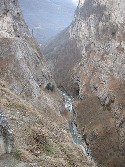
 Cherek Narrows Cherek Narrows | |
  | |
| Location | |
| Country | Kabardino-Balkaria (Russia) |
| Physical characteristics | |
| Source | |
| • location | Greater Caucasus |
| Mouth | Baksan |
| • coordinates | 43°42′01″N 44°03′02″E / 43.7004°N 44.0506°E / 43.7004; 44.0506 |
| Length | 79 km (49 mi) |
| Basin size | 3,070 km (1,190 sq mi) |
| Basin features | |
| Progression | Baksan→ Malka→ Terek→ Caspian Sea |
The Cherek (Russian: Черек) is a river in Kabardino-Balkaria in Russia, a right tributary of the Baksan (Terek basin). The Cherek is 79 kilometres (49 mi) long and drains a basin of 3,070 square kilometres (1,190 sq mi). The Cherek is formed by the confluence of the Cherek-Balkarsky and Cherek-Khulamsky, both of which originate in the glaciers of the northern slopes of the Greater Caucasus, one of them being the Bezengi Glacier. The river Nalchik flows into the Urvan, which is a branch of the Cherek.
Gallery
References
- ^ Черек, Great Soviet Encyclopedia
- "Река Черек in the State Water Register of Russia". textual.ru (in Russian).
- "Водоток Урвань, проток р. Черек in the State Water Register of Russia". textual.ru (in Russian).
This Kabardino-Balkaria location article is a stub. You can help Misplaced Pages by expanding it. |
This article related to a river in the North Caucasian Federal District of Russia is a stub. You can help Misplaced Pages by expanding it. |


