Mountain in Russia For the mountain in the Baikal Range, see Mount Chersky.
| Chersky Peak | |
|---|---|
| Пик Черского / Хара-Болдог | |
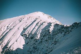
 View of the peak in February View of the peak in February | |
| Highest point | |
| Elevation | 2,090 m (6,860 ft) |
| Prominence | 352 m (1,155 ft) |
| Coordinates | 51°30′56″N 103°37′33″E / 51.51556°N 103.62583°E / 51.51556; 103.62583 |
| Geography | |
 | |
| Location | Irkutsk Oblast Russian Far East |
| Parent range | Khamar-Daban, South Siberian Mountains |
Chersky Peak (Russian: Пик Черского; Buryat: Хара-Болдог) is a mountain in the Komarinsky Range, Khamar-Daban, Russian Federation.
This peak is named after Polish explorer Jan Czerski (1845–1892), who greatly contributed to the study of neighboring Lake Baikal.
Geography
This 2,090 m high peak is one of the highest points of the Khamar-Daban Range, part of the South Siberian System of ranges. It rises in the Komarinsky subrange of the Khamar-Daban. Administratively the Chersky Peak is part of the Slyudyansky District, at the southern end of Irkutsk Oblast. Lake Serdtse is located below the southern slopes of the mountain.
See also
References
- ^ "Pik Cherskogo". PeakVisor.
- Природа Байкала - вершина Пик Черского (in Russian)
- Google Earth
External links
 Media related to Chersky Peak at Wikimedia Commons
This Irkutsk Oblast location article is a stub. You can help Misplaced Pages by expanding it. |