| Chocón Machacas Protected Biotope | |
|---|---|
| IUCN category IV (habitat/species management area) | |
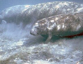
 The reserve has a Caribbean manatee population The reserve has a Caribbean manatee population | |
| Location | Izabal, Guatemala |
| Coordinates | 15°46′N 88°53′W / 15.767°N 88.883°W / 15.767; -88.883 |
| Area | 62.65 km (24.19 sq mi) |
| Established | Decreto Legislativo 4-89 |
| Visitors | allowed |
| Operator | CECON / USAC |
The Chocón Machacas Protected Biotope is a protected nature reserve in eastern Guatemala. It is located in the municipality of Livingston, in a densely forested area covering the lower reaches of the Chocón Machacas River basin and the northern shores of the Río Dulce-Golfete Dulce system (15°45′20″N 88°52′24″W / 15.755464°N 88.873243°W / 15.755464; -88.873243 (Chocón Machacas Protected Biotope)).
The Chocón Machacas river and Golfete Dulce complex form one of Guatemala's few remaining habitats for the endangered Caribbean manatee (Trichechus manatus).
References
- CONAP. "Listado de Áreas Protegidas (enero, 2011)" (in Spanish). conap.gob.gt. Archived from the original (xls) on 2011-10-08. Retrieved 2011-06-14.
- Parkswatch. "Chocón Machacas Protected Biotope". parkswatch.org. Retrieved 2009-08-07.
- Self-Sullivan, C.; Mignucci-Giannoni, A. (2008). "Trichechus manatus ssp. manatus. In: IUCN 2009. IUCN Red List of Threatened Species. Version 2009.1". iucnredlist.org. Retrieved 2009-08-07.
- Yañez-Arancibia, Alejandro; David Zárate Lomelí; Angel Terán Cuevas (1995). Evaluation of the coastal and marine resources of the Atlantic Coast of Guatemala (PDF). UNEP. Archived from the original (pdf) on 2011-07-19. Retrieved 2011-03-07.
- Castillo Lemus, Noé Ariel (2005). Estudio de identificación y caracterización preliminar de corredores biológicos con conectividad al biotopo Chocón Machacas (PDF). Archived from the original (pdf) on 2011-07-14. Retrieved 2011-03-07.
This Guatemala location article is a stub. You can help Misplaced Pages by expanding it. |
This article related to a protected area in North America is a stub. You can help Misplaced Pages by expanding it. |