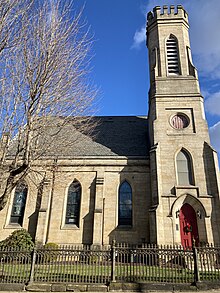
Church in Pennsylvania, United States
| Christ Church | |
|---|---|
 | |
| Location | 319 Church Street, Brownsville, Pennsylvania |
| Country | United States |
| Denomination | Anglican Church in North America |
| Website | https://www.christanglicanchurchbrownsvillepa.org/ |
| History | |
| Founded | 1813 |
| Dedicated | 1859 |
| Architecture | |
| Style | Gothic Revival |
| Years built | 1857 |
| Administration | |
| Diocese | Pittsburgh |
| Clergy | |
| Rector | The Rev. G. Keith Almond |
| Deacon(s) | The Rev. Don Bower |
| Christ Episcopal Church | |
| U.S. Historic district Contributing property | |
| Part of | Brownsville Northside Historic District (ID93000717) |
| Added to NRHP | August 2, 1993 |
Christ Church is a historic Anglican church in Brownsville, Pennsylvania. Completed in 1857, the church is a contributing property to the Brownsville Northside Historic District.
History
The congregation traces its origins to 1759, when Anglican services in what is present-day Brownsville were held by British troops establishing the Redstone Old Fort during the French and Indian War. The parish was formally recognized by the Diocese of Pennsylvania in 1813. Until the 1820s, Anglican worship took place quietly in private log churches along the National Pike amid anti-English prejudice. In 1796, Anglicans purchased the present-day grounds of the church for constructing a church in the newly established town of Brownsville. The first church was completed in 1823. and consecrated by Bishop William White in 1825. The second and present stone church was built in 1857 and consecrated in 1859, remaining in continual use since then.
In 2008, as part of the Anglican realignment, Christ Church joined the majority of the Episcopal Diocese of Pittsburgh in disassociating from the Episcopal Church and forming the Anglican Diocese of Pittsburgh under Bishop Robert Duncan.
Architecture
Christ Church's present building was designed in the Gothic Revival style and built of cut sandstone. The church features a crenellated bell tower on its southern corner along with a steeply pitched slate roof, three window bays on each side featuring stained glass tracery windows, stone buttresses and a chancel.
Next to the church is a two-story, five-bay vernacular brick house that once served as the Christ Church rectory and is currently used for offices and classrooms. According to the National Register of Historic Places nomination form, "The former parsonage has a stone foundation, a shingles-clad gable roof with double chimneys and curtains at gable ends, and a center Greek Revival doorway surrounded by sidelights, transom and a large, flat, stone lintel." Across the street is a stone parish hall built in 1873; it also has a steeply pitched slate roof and Gothic windows with an adjacent 1908 addition.
Cemetery

The Christ Church cemetery is located directly northeast of the church and is surrounded by an iron picket fence. Notable burials in the cemetery include Thomas Brown, the founder of Brownsville, and two cousins of George Washington: John H. Washington and Archibald Washington.
Ministries
Christ Church holds weekly Eucharistic services, Bible studies and various outreach ministries.
References
- ^ "Brownsville Northside Historic District Nomination Form". National Register of Historic Places. Retrieved January 2, 2024.
- ^ "Our Beginning". Christ Anglican Church Brownsville. Retrieved January 2, 2024.
- "Churches in Union with the Diocese" (PDF). The 156th Convention Journal of the Anglican Diocese of Pittsburgh. 156: 5. Retrieved January 2, 2024.
- Gundersen, Joan R. (2013). "A History of the Episcopal Church in the Diocese of Pittsburgh". Episcopal Diocese of Pittsburgh. Retrieved January 2, 2024.
- Borsodi Zajac, Frances (September 30, 2008). "Local churches align with deposed bishop". Herald Standard. Retrieved January 2, 2024.
External links
40°01′25″N 79°52′47″W / 40.02359°N 79.87981°W / 40.02359; -79.87981
Categories:- Anglican Church in North America church buildings in the United States
- Religious organizations established in 1813
- Churches completed in 1857
- Historic district contributing properties in Pennsylvania
- Churches in Fayette County, Pennsylvania
- Anglican realignment congregations
- 19th-century Anglican church buildings in the United States