Neighbourhood in Mumbai City, Maharashtra, India
| Churchgate | |
|---|---|
| Neighbourhood | |
 The original gate which led to the present day St. Thomas Cathedral in 1863 was later dismantled. The original gate which led to the present day St. Thomas Cathedral in 1863 was later dismantled. | |
   | |
| Coordinates: 18°56′N 72°49′E / 18.93°N 72.82°E / 18.93; 72.82 | |
| Country | India |
| State | Maharashtra |
| District | Mumbai City |
| City | Mumbai |
| Government | |
| • Type | Municipal Corporation |
| • Body | Brihanmumbai Municipal Corporation (MCGM) |
| Languages | |
| • Official | Marathi |
| Time zone | UTC+5:30 (IST) |
| PIN | 400020 |
| Area code | 022 |
| Vehicle registration | MH 01 |
| Civic agency | BMC |

Churchgate (Marathi pronunciation: ) is an area in the southern part of Mumbai, close to the Arabian Sea. The area is known for its unique architecture consisting of art deco style residential buildings, access to sporting venues, and the business district of Nariman Point.
History
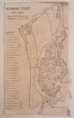
During the eighteenth and up to the mid-19th century, Mumbai was a walled city surrounded by a fortification. The city walls had three gates. One of the gates, Churchgate, was named after St. Thomas Cathedral, Mumbai. The area west of the original gate came to be known as Churchgate. In the mid-19th century, the wall of the fort along with its gates were torn down to aid in the expansion of the city. At the exact location of the Churchgate, Flora Fountain was built.
Geography
Arabian Sea is situated at west and Nariman Point on south of Churchgate. Churchgate railway station is a major railway terminus on the Western line of the Mumbai Suburban Railway.
2008 Mumbai attacks
On 26 November 2008, a Pakistan trained Lashkar-e-Taiba terrorist attacked the Trident hotel and the Oberoi hotel. This attack ended up killing as many as 30 people. The hotels are situated on the southern border of Churchgate in the Nariman Point area. The attacks were part of a larger Mumbai terrorist attack, which killed 166 and injured 238 in an unprecedented Islamic terrorist attack. In response, Mumbai police killed one terrorist and apprehended another, Ajmal Kasab, along with which the National Security Guards (NSG) killed 8 other terrorists.
Metro
Mumbai Metro's Aqua Line (Line 3) will pass through Churchgate area, with its route covering Colaba-Bandra-Seepz. Hutatma Chowk, Churchgate and Vidhan Bhavan are the stations listed for this area, and all of these will be built underground. Line 3 is expected to reduce road congestion as well as the load on the Western Line between Bandra and Churchgate.
Places
Following places are located in Churchgate area of Mumbai:
- Cricket centre - headquarters and office of Board of Control for Cricket in India
- Wankhede stadium - an international cricket Stadium
- Mumbai Cricket Association - headquarters of Mumbai cricket
- Marine drive - a seaside road
- Cricket Club of India (CCI)- an exclusive sports club for rich elites
- Brabourne Stadium - an old cricket stadium, owned by CCI
- Churchgate railway station
Colleges
- K.C College
- K.C. Law College
- Jamnalal Bajaj Institute of Management Studies
- H.R. College of Commerce and Economics
- Government Law College, Mumbai
- Jai Hind College
- Sydenham College
- Elphinstone College
- SNDT Women's University
Sights
Tourist spots in the Churchgate area include:
- Hutatma Chowk
- Maharashtra High Court
- Marine Drive
- Oval Maidan
 1 1 | |||||
| |||||
.
References
- Imrani, Mishkaat (27 April 2022). "Flora Fountain's book street in Mumbai is a gem for all bibliophiles!". Shop Local Samosa. Archived from the original on 12 October 2022. Retrieved 12 October 2022.
- Pasricha, P. S. (February 1983). "Pedestrian Planning in Greater Bombay". Traffic Engineering & Control. 24 (2). ISSN 0041-0683. Archived from the original on 31 August 2023. Retrieved 12 October 2022.
- Kagra, Hemant; Sonare, Prashant (October 2011). "Train management system for Mumbai Suburban train network - an operations perspective". 2011 5th International Conference on Application of Information and Communication Technologies (AICT). pp. 1–5. doi:10.1109/ICAICT.2011.6111027. ISBN 978-1-61284-832-7. S2CID 14719325. Archived from the original on 31 August 2023. Retrieved 4 January 2023.
- "Eleven years since 26/11 Mumbai terror attacks". Archived from the original on 31 August 2023. Retrieved 13 December 2022.
- "26/11: The day terror hit us". 26 November 2021. Archived from the original on 31 August 2023. Retrieved 15 October 2022.
| Mumbai metropolitan area | |
|---|---|
| South Mumbai | |
| Navi Mumbai | |
| Eastern Suburbs | |
| Western Suburbs | |
| Mira-Bhayandar (Thane district) | |
| Thane (Thane district) | |
| Kalyan-Dombivli (Thane district) | |
| Ulhasnagar (Thane district) | |
| Bhiwandi-Nizampur (Thane district) | |
| Vasai-Virar (Palghar district) | |
| Suburbs in Raigad district | |
This Mumbai location article is a stub. You can help Misplaced Pages by expanding it. |