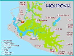

Clara Town is a slum located on Bushrod Island in Monrovia, the capital of Liberia. It is built upon a swamp. Clara Town was one of several ethnic communes that was squatted in the outskirts of Monrovia. Clara Town had around 4,500 inhabitants in 1964 out of whom 99% were Kru.
An area within Clara Town is named "Struggle Community". According to The New Humanitarian this zone is "a network of haphazard, rubbish-strewn streets, many of which are flooded for several months of the year". In this area, 10,000 residents share two privately owned water taps. Clara Town's 75,000 people shared 11 public toilets and 22 public taps in 2009.
Notable people
- George Weah, former soccer player and president of Liberia.
References
- "Maps of Major Streets in Monrovia". Archived from the original on 16 May 2008. Retrieved 8 December 2008.
- ^ "LIBERIA: Disease rife as more people squeeze into fewer toilets", IRIN News, 19 November 2009.
- Robert A. Obudho; Constance C. Mhlanga (1988). Slum and Squatter Settlements in Sub-Saharan Africa: Toward a Planning Strategy. Praeger. p. 45. ISBN 978-0-275-92309-9.
- Willi Schulze (1973). Liberia: länderkundl. Dominanten u. regionale Strukturen. Wissenschaftliche Buchgesellschaft. p. 131. ISBN 978-3-534-05821-1.
- Talk Football, "Liberian Football Legend Profile: George Weah"
6°20′N 10°48′W / 6.333°N 10.800°W / 6.333; -10.800
Categories: