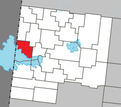
Municipality in Quebec, Canada
Clerval (French pronunciation: [klɛʁval] ) is a municipality in northwestern Quebec , Canada , in the Abitibi-Ouest Regional County Municipality . It covers 101.6 km² and had a population of 373 as of the 2021 Canadian census .
The municipality was incorporated on September 12, 1927, and originally called Sainte-Jeanne-d'Arc-de-Clerval. Likely the current name, adopted in 1951, is a portmanteau from the French words claire vallée , meaning "clear valley".
In addition to Clerval itself, the municipality also includes the community of L'Île-Nepawa (48°41′12″N 79°27′22″W / 48.68667°N 79.45611°W / 48.68667; -79.45611 Lake Abitibi . Nepawa comes from the Algonquin language meaning "where one camps in passing" or "large island".
Demographics
Historical census populations – Clerval, Quebec Year Pop. ±% 1931 486 — 1941 765 +57.4% 1951 845 +10.5% 1956 852 +0.8% 1961 775 −9.0% 1966 666 −14.1%
Year Pop. ±% 1971 481 −27.8% 1976 374 −22.2% 1981 380 +1.6% 1986 365 −3.9% 1991 346 −5.2% 1996 356 +2.9%
Year Pop. ±% 2001 351 −1.4% 2006 358 +2.0% 2011 364 +1.7% 2016 371 +1.9% 2021 373 +0.5%
Source: Statistics Canada
Private dwellings occupied by usual residents (2021): 180 (total dwellings: 291)
Mother tongue (2021):
English as first language: 1.3%
French as first language: 96%
English and French as first language: 1.3%
Other as first language: 0% Government
Municipal council (as of 2023):
Mayor: Michel Cliche
Councillors: Gaétan St-Jean, Claire Paquet, Mathilde Lévesque, Chantal Melançon, Nancy Gosselin, Nicole Therrien References
^ "Clerval (Municipalité)" (in French). Commission de toponymie du Québec. Retrieved 2011-01-07.
^ "Clerval" . Répertoire des municipalités (in French). Ministère des Affaires municipales et de l'Habitation. Retrieved 2023-07-06.
^ "Clerval, Quebec (Code 2487075) Census Profile" . 2021 census Statistics Canada .
"L'Île-Nepawa (Hameau)" (in French). Commission de toponymie du Québec. Retrieved 2011-01-10."Île Nepawa" (in French). Commission de toponymie du Québec. Retrieved 2011-01-10.
External links
Adjacent Municipal Subdivisions
Categories :
Text is available under the Creative Commons Attribution-ShareAlike License. Additional terms may apply.
**DISCLAIMER** We are not affiliated with Wikipedia, and Cloudflare.
The information presented on this site is for general informational purposes only and does not constitute medical advice.
You should always have a personal consultation with a healthcare professional before making changes to your diet, medication, or exercise routine.
AI helps with the correspondence in our chat.
We participate in an affiliate program. If you buy something through a link, we may earn a commission 💕
↑

 Location within Abitibi-Ouest RCM
 Media related to Clerval, Quebec at Wikimedia Commons