You can help expand this article with text translated from the corresponding article in French. (December 2009) Click for important translation instructions.
|
| Corenc | |
|---|---|
| Commune | |
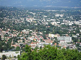
 Corenc is in the background; in the foreground is La Tronche Corenc is in the background; in the foreground is La Tronche | |
 Coat of arms Coat of arms | |
| Location of Corenc | |
  | |
| Coordinates: 45°12′44″N 5°45′05″E / 45.2122°N 5.7514°E / 45.2122; 5.7514 | |
| Country | France |
| Region | Auvergne-Rhône-Alpes |
| Department | Isère |
| Arrondissement | Grenoble |
| Canton | Meylan |
| Intercommunality | Grenoble-Alpes Métropole |
| Government | |
| • Mayor (2020–2026) | Jean-Damien Mermillod-Blondin |
| Area | 6.5 km (2.5 sq mi) |
| Population | 4,177 |
| • Density | 640/km (1,700/sq mi) |
| Time zone | UTC+01:00 (CET) |
| • Summer (DST) | UTC+02:00 (CEST) |
| INSEE/Postal code | 38126 /38700 |
| Elevation | 221–1,328 m (725–4,357 ft) (avg. 467 m or 1,532 ft) |
| French Land Register data, which excludes lakes, ponds, glaciers > 1 km (0.386 sq mi or 247 acres) and river estuaries. | |
Corenc (French pronunciation: [kɔʁɑ̃]) is a commune in the département of Isère in southeastern France. It is part of the Grenoble urban unit (agglomeration).
Geography
Corenc is situated in the Alps near the center of the département of Isère.
Population
|
| ||||||||||||||||||||||||||||||||||||||||||||||||||||||||||||||||||||||||||||||||||||||||||||||||||||||||||||||||||
| Source: EHESS and INSEE (1968-2017) | |||||||||||||||||||||||||||||||||||||||||||||||||||||||||||||||||||||||||||||||||||||||||||||||||||||||||||||||||||
Economy
In 2007, Corenc's per capita income of €30,742 was the highest of any commune of France outside of the Paris region, and was nearly double the national average of €15,849.
See also
References
- "Répertoire national des élus: les maires". data.gouv.fr, Plateforme ouverte des données publiques françaises (in French). 2 December 2020.
- "Populations de référence 2022" (in French). The National Institute of Statistics and Economic Studies. 19 December 2024.
- Unité urbaine 2020 de Grenoble (38701), INSEE
- Des villages de Cassini aux communes d'aujourd'hui: Commune data sheet Corenc, EHESS (in French).
- Population en historique depuis 1968, INSEE
External links
This Isère geographical article is a stub. You can help Misplaced Pages by expanding it. |