Misplaced Pages

Coyote Creek Trail

Article snapshot taken from Wikipedia with creative commons attribution-sharealike license. Give it a read and then ask your questions in the chat. We can research this topic together.
Cycling and pedestrian trail in San Jose and Santa Clara County, California This article is about the trail in San Jose and Santa Clara County, California. For the bicycle path in Los Angeles, see Coyote Creek bicycle path. For the backcountry trail in Wyoming and Montana, see Trails of Yellowstone National Park.

Coyote Creek Trail
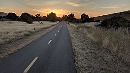
Coyote Creek Trail near Bailey at sunset
Length18.7 miles (30.1 km)
LocationSanta Clara County, California
DesignationNational Recreation Trail
Surfacepaved

The Coyote Creek Trail is a pedestrian and cycling trail along Coyote Creek in San Jose, California, which continues into Coyote Valley and northern Morgan Hill. The Coyote Creek Trail was designated part of the National Recreation Trail system in 2009. It is also part of the Bay Area Ridge Trail system.

Coyote Creek Trail in San Jose

National Recreation Trail
Bay Area Ridge Trail
Legend
Robert Louis Stevenson State Park
Mt St Helena 4,342 ft (1,323 m)
Lower Oat Hill Mine Trail Duff and Wildlake Ranches
Napa River Las Posadas State Forest
Bothe-Napa Valley State Park Moore Creek Park
Sugarloaf Ridge State Park
Bald Mtn 2,729 ft (832 m)
Napa County
Sonoma County
Rector Watershed
Hood Mtn Regional Park
Mt Hood 2,733 ft (833 m)
Atlas Peak
Spring Lake and Howarth Parks Milliken Watershed
Annadel State Park
Bennett Mtn 1,887 ft (575 m)
Skyline Wilderness Park
North Sonoma Mtn Regional Park & Preserve
Sonoma Mtn 2,463 ft (751 m)
Napa County
Solano County
Jack London State Historic Park Vallejo Lakes Watershed
Rockville Trails Preserve
Rancho Petaluma Adobe Rockville Hills Regional Park
Helen Putnam Regional Park Vintage Valley Trail
Sonoma County
Marin County
Lynch Canyon Open Space Park
McGary Rd
Olompali State Historic Park
(L) Hiddenbrooke
(R) Vallejo King-Swett Ranches
Mount Burdell Open Space Preserve
Mt Burdell 1,558 ft (475 m)
Benicia State Recreation Area
Indian Tree Open Space Preserve
Alfred Zampa span of Carquinez Bridge
← to San Francisco Bay Trail
Lucas Valley Open Space Preserve
Solano County
Contra Costa County
Benicia–Martinez Bridge
Samuel P. Taylor State Park Crockett Hills Regional Park
Gary Giacomini & White's Hill Open Space Preserves
Green Hill 1,418 ft (432 m)
Carquinez Strait Regional Shoreline
Loma Alta Open Space Preserve
Loma Alta 1,592 ft (485 m)
Fernandez Ranch
Bolinas Ridge
John Muir National Historic Site
Mt Wanda 640 ft (200 m)
Mount Tamalpais State Park
Mt Tamalpais 2,571 ft (784 m)
Pinole Valley Watershed
Muir Beach Overlook Sobrante Ridge Regional Park
Marin Headlands
Wildcat Canyon Regional Park
Wildcat Peak 1,250 ft (380 m)
Golden Gate Bridge
Marin County
San Francisco City & County
Tilden Regional Park
Vollmer Peak 1,905 ft (581 m)
Presidio
→ to San Francisco Bay Trail
Contra Costa County
Alameda County
Sibley Volcanic Preserve
Round Top 1,763 ft (537 m)
Twin Peaks
Twin Peaks 925 ft (282 m)
Redwood Regional Park
Redwood Peak 1,619 ft (493 m)
Lake Merced & Stern Grove  (West Portal) Anthony Chabot Regional Park
San Francisco City & County
San Mateo County
Cull Canyon Regional Recreation Area
Milagra Ridge Bay Area Rapid Transit (Daly City) Five Canyons Open Space
Sweeney Ridge Stonebrae Country Club
Peninsula Watershed Garin & Dry Creek Regional Parks
Purisima Creek Redwoods Open Space Preserve
El Corte de Madera Creek Open Space Preserve
Sierra Morena 2,417 ft (737 m)
Vargas Plateau Regional Park
La Honda Creek Open Space Preserve
Windy Hill Open Space Preserve
Windy Hill 1,905 ft (581 m)
Mission Peak Regional Preserve
Mission Peak 2,517 ft (767 m)
Russian Ridge Open Space Preserve
Alameda County
Santa Clara County
Skyline Ridge Open Space Preserve
Ed R. Levin County Park
Monument Peak 2,594 ft (791 m)
San Mateo County
Santa Cruz County
Sierra Vista Open Space Preserve
Long Ridge Open Space Preserve
Alum Rock Park
Penitencia Creek Trail
Saratoga Gap Open Space Preserve Bay Area Rapid Transit (Berryessa/​North San José)
Castle Rock State Park
Castle Rock 3,214 ft (980 m)
Grant Ranch County Park
Santa Cruz County
Santa Clara County
Coyote Creek Trail
Sanborn County Park Santa Teresa County Park
El Sereno Open Space Preserve Almaden Quicksilver County Park
Sierra Azul Open Space Preserve
El Sombroso 2,999 ft (914 m)
Coyote–Bear County Park
Mt Umunhum 3,486 ft (1,063 m)
Loma Prieta 3,790 ft (1,160 m)
Mount Madonna County Park
Mt Madonna 1,897 ft (578 m)

Legend
Bold bridges
Italic trails
Small italic prominent physical features
  completed trails
  planned trails
transit station

The northern portion of the trail is in the San Jose city limits. The northernmost point is at the southern tip of San Francisco Bay. The trail is not yet continuous within San Jose. A paved section exists between the Highway 237 Bikeway and Tasman Drive. A short disconnected segment is at Berryessa Road at the San Jose Flea Market and Berryessa BART Station. The trail is paved from Tully Road south for 2 miles to the end of the city-maintained segment at Hellyer County Park, where the paved county section continues.

Ecological artist Deborah Kennedy was commissioned by the San Jose Public Art Program to work alongside sculptor Diana Pumpelly Bates in 2004 on completion of a community project for the Coyote Creek Trail. Their public artworks, including Kennedy's 'Ripple Effect' and Bates 'Run River Run', are used to promote public awareness of a concrete landing pad and ramp leading to a levee where strollers, wheelchairs, and bicyclists have greater accessibility to the site.

Coyote Creek Parkway

The southern county-maintained portion of the Coyote Creek Trail is part of the Coyote Creek Parkway, which includes the trail and a chain of county parks along the creek. The county portion is 15 miles of paved trail from Hellyer Park to Anderson Lake.

Landmarks

Gallery

  • Tully Road trailhead of the Coyote Creek Trail in San Jose Tully Road trailhead of the Coyote Creek Trail in San Jose
  • Coyote Creek Trail at Coyote Creek Lake Coyote Creek Trail at Coyote Creek Lake
  • Bridge over Coyote Creek on the Coyote Creek Trail Bridge over Coyote Creek on the Coyote Creek Trail
  • Coyote Creek Trail crosses the creek near Bailey Avenue Coyote Creek Trail crosses the creek near Bailey Avenue

References

  1. ^ "Coyote Creek Trail". American Trails. Retrieved June 14, 2019.
  2. "South Bay Trail Maps". Bay Area Ridge Trail. Retrieved June 17, 2019.
  3. "Coyote Creek". City of San Jose. Retrieved June 13, 2019.
  4. ^ "Ripple Effect and Run River Run; Artists: Deborah Kennedy and Diana Pumpelly Bates". City of San Jose Public Art Program. April 2004. Archived from the original on August 1, 2019. Retrieved August 2, 2019.
  5. "Coyote Creek Parkway". Santa Clara County. Retrieved June 13, 2019.

External links

Morgan Hill, California
Buildings
Education
Events, history, and culture
Natural monuments
Neighborhoods
Radio stations
Related
Category
Santa Clara County Parks
Parks
Other
List of tourist attractions in Santa Clara Valley
Arboreta & gardens
Cultural organizations
Event venues
Performing arts
venues
Sports venues
Civic venues
Events
Historical
Historic buildings
Historic areas
Museums
Art
History
Science
Parks & trails
Shopping
Theme parks & tours
Vineyards & wineries
Parks and public spaces of San Jose, California
Parks & gardens
Plazas & squares
Paseos
Trails
Municipal golf courses
Other
Hiking trails in California
Interstate
Bay Area
Sierra Nevada
Southern California
Other
Categories: